
- Home

- Watersheds - Fox
- Search Results
Search Results
Search Results For:
Watershed > Fox
45 links were found.
Displaying Page 1 (of 3)
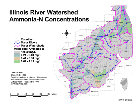
Maps/GIS- 1 Ammonia-N Concentrations in the Illinois River Watershed
- Thematic map showing the mean total Ammonia-N for each of the major sub-watersheds.
- Download Options: LoRes preview | HiRes (624 K) | Metadata
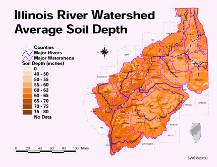
- 2 Average soil depth in the Illinois River Watershed
- Thematic map showing the average soil depth (inches) across the basin.
- Download Options: LoRes preview | HiRes (3.36 MB) | Metadata
- 3 Cook County Orthophotography Data 1998-1999
- Illinois National Aerial Photography Program Digital Orthophotography quarter Quadrangle data for Cook County in the Universal Transverse Mercator (UTM) coordinate system with a NAD83 datum.

- 4 De Kalb County Orthophotography Data 1998-1999
- Illinois National Aerial Photography Program Digital Orthophotography quarter Quadrangle data for De Kalb County in the Universal Transverse Mercator (UTM) coordinate system with a NAD83 datum.
- 5 Dupage County Orthophotography Data 1998-1999
- Illinois National Aerial Photography Program Digital Orthophotography quarter Quadrangle data for Dupage County in the Universal Transverse Mercator (UTM) coordinate system with a NAD83 datum.
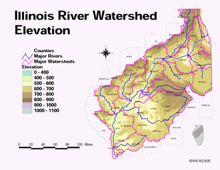
- 6 Elevation in the Illinois River Watershed
- Thematic map showing elevation changes in the basin.
- Download Options: LoRes preview | HiRes (1.76 MB) | Metadata
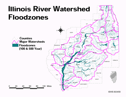
- 7 Floodzones in the Illinois River Watershed
- Thematic map showing the 100 and 500 year floodzones across the basin as of 1986.
- Download Options: LoRes preview | HiRes (3.77 MB) | Metadata
- 8 Fox River Tributary Watersheds and Subwatersheds
- Fox River Tributary watersheds and subwatersheds (62 individual shapefiles) created through BASINS automatic delineation, as part of the Fox River Watershed Investigation (shapefile, .zip archive). Note - To download individual shapefiles, visit the Fox River Tributary Watershed GIS Page: http://ilrdss.sws.uiuc.edu/fox/tributaries_gis.aspx
- 9 Fox Watershed - Ambient Water Quality Monitoring Network (AWQMN)
- The Ambient Water Quality Monitoring Network is managed by the Illinois Environmental Protection Agency. This data set shows locations of all fixed monitoring sites in the Fox Watershed. This data is a sub-set of a state-wide data set. Data set was generated from location data created by the IEPA (in latitude/longitude, decimal degree format). (shapefile, .zip archive)
- 10 Fox Watershed - Boundary
- This geospatial dataset is the Fox watershed boundary derived from the Illinois HUC12 (ilhuc12geo83) hydrologic unit boundary layer which was developed by delineating the boundary lines on 1:24,000 base maps and digitizing the delineated lines. Digital Elevation Model data may have been used in part of the process to establish preliminary boundaries. (shapefile, .zip archive)
- 11 Fox Watershed - Census blocks (2000, 2002)
- U.S. Block Groups represents the Census block groups clipped to the Fox watershed boundary derived from the Illinois HUC12 (ilhuc12geo83) hydrologic unit boundary layer which was developed by delineating the boundary lines on 1:24,000 base maps. (shapefile, .zip archive)
- 12 Fox Watershed - Combined Sewer Overflow (CSO)
- This dataset describes Combined Sewer Overflows (CSOs) in the Fox River watershed in Illinois. The location was displayed using geographical coordinates in NPDES permit applications provided by Walter E. Deuchler Associates, Inc. (Aurora) and Fox River Water Reclamation District (Elgin). The data was submitted to the Fox River Study Group, Inc. (FRSG) for verification. The location of Aurora CSOs was manually adjusted to match outfall position (map provided by Walter E. Deuchler Associates, Inc. in January 2004) using digital ortho quadrants (DOQs). (shapefile, .zip archive)
- 13 Fox Watershed - County boundaries
- This is an Arc/Info polygon and arc data set containing county boundaries in Illinois. Some county boundaries are also state boundary lines, Indian treaty boundary lines, township and range lines, or section boundaries and are identified as such. County polygons are labeled with county name and FIPS designation. Nominal scale is 1:62,500. This is only a subset of the original data set. It contains only counties in Illinois in which the Fox River watershed is located. (shapefile, .zip archive)
- 14 Fox Watershed - Dams
- This shapefile shows the location of dams in the Fox River and contains information associated with the dams. (shapefile, .zip archive)
- 15 Fox Watershed - Discharge Gages
- This feature class represents discharge gages within the Fox River Basin within Illinois. (shapefile, .zip archive)
- 16 Fox Watershed - HUC 12 Watershed boundaries
- This geospatial dataset is a hydrologic unit boundary layer that is at the Subwatershed (12-digit) level clipped to the Fox watershed boundary derived from the Illinois HUC12 (shapefile, .zip archive)
- 17 Fox Watershed - Lakes
- This feature class represents lakes within the Fox River Basin within Illinois. (shapefile, .zip archive)
- 18 Fox Watershed - Land use/Land cover
- Illinois State Geological Survey Statewide Arc/Info GRID coverage of the Land Cover of Illinois1999-2000, clipped to the HUC12 Fox Watershed boundaries. Charles Foor, IDNR, reprojected the data from UTM16, GRS1980, NAD83 to the Lambert Conformal Conic. (GRID, .zip archive)
- 19 Fox Watershed - National Hydrography Dataset (NHD) - Entire basin
- The National Hydrography Dataset (NHD) is a national hydrographic data set which describes surface water resources in the United States. The Fox NHD-reach data represents a small portion of this extensive data resource. This data describes stream/river reaches in the entire Fox watershed (both Wisconsin and Illinois portions) and was created from the route.rch data in the Arc/Info coverage. Polyline M features were maintained in this version. For complete metadata for the NHD, visit http://nhd.usgs.gov/index.html (shapefile, .zip archive)
- 20 Fox Watershed - National Hydrography Dataset (NHD) - Illinois portion
- The National Hydrography Dataset (NHD) is a national hydrographic data set which describes surface water resources in the United States. The Fox-huc12-nhd reach data represents a small portion of this extensive data resource, clipped from the Fox watershed boundary derived from the Illinois HUC12 (ilhuc12geo83) hydrologic unit boundary layer which was developed by delineating the boundary lines on 1:24,000 base maps. This data describes stream/river reaches in the Fox watershed (Illinois portions) and was created from the route.rch data in the Arc/Info coverage. Polyline M features were maintained in this version. For complete metadata for the NHD, visit http://nhd.usgs.gov/index.html (shapefile, .zip archive)
- Home
- | Data
- | Maps/GIS
- | Models
- | Publications
- | Research
- | Agencies
- | Visualizations
All files and information © 2018 Illinois State Water Survey. Disclaimer.
Email the Web Administrator with questions or comments.