
- Home

- Watersheds - Fox
- Search Results
Search Results
Search Results For:
Watershed > Fox
45 links were found.
Displaying Page 3 (of 3)
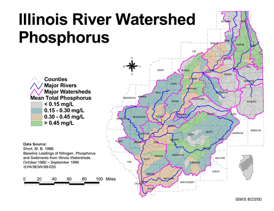
Maps/GIS- 41 Phosphorus in the Illinois River Watershed
- Thematic map showing the mean total phosphorus concentrations for each of the major sub-watersheds.
- Download Options: LoRes preview | HiRes (624 K) | Metadata
- 42 Resource Management Mapping Service
- Interactive map that allows users to locate, create, and print maps of large and small areas within Illinois. Natural resource, administrative, and economic layers available.
- 43 Sediment delivery to the main stem of the Illinois River
- Using sediment delivery classes, this map describes sediment delivery to the Illinois River from the major sub-watersheds.
- Download Options: LoRes preview | HiRes (630 K) | Metadata
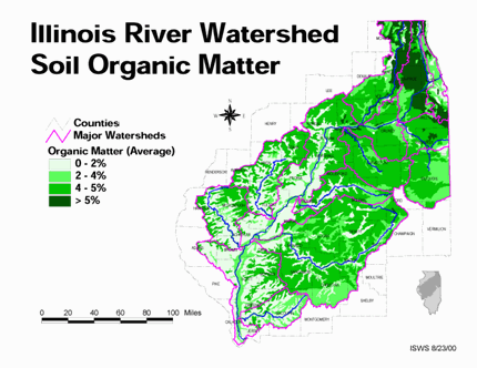
- 44 Soil organic matter in the Illinois River Watershed
- Thematic map showing the percent organic matter for each of the major sub-watersheds.
- Download Options: LoRes preview | HiRes (4.69 MB) | Metadata
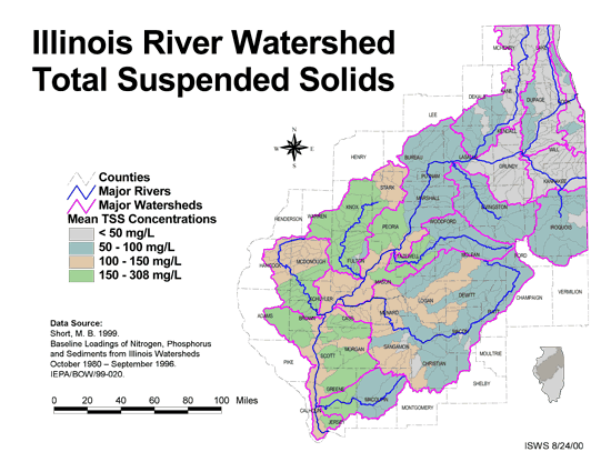
- 45 Total suspended solids in the Illinois River Watershed
- Thematic map showing the mean TSS concentrations for each of the major sub-watersheds.
- Download Options: LoRes preview | HiRes (626 K) | Metadata
- Home
- | Data
- | Maps/GIS
- | Models
- | Publications
- | Research
- | Agencies
- | Visualizations
All files and information © 2018 Illinois State Water Survey. Disclaimer.
Email the Web Administrator with questions or comments.