
- Home
 Emiquon Home
- Emiquon Modeling
Emiquon Hydrologic and Hydraulic Modeling
The Illinois River has experienced significant changes in hydrology. Over time these changes have resulted in environmental and ecological degradation along the river. With this realization, major restoration efforts are underway to improve the hydrology, water quality, and habitats along the river and its watershed. A major challenge in these restoration efforts is the proper understanding of the watershed hydrology and river hydraulics so that watersheds and rivers are managed in such a way to promote and sustain ecological restoration, while maintaining the economical functions of the river.
In support of this effort, the Illinois State Water Survey is developing hydrologic and hydraulic models to guide and evaluate the impacts of proposed or ongoing restoration efforts in the Illinois River basin. One of the major restoration concepts focuses on the management of the river/floodplain complex. The Lower Illinois River floodplain is extensive; over 30 levee and drainage districts have been established in the floodplain for agricultural production. Some levee and drainage districts have been purchased by state, federal, and non-governmental organizations for the purposes of "restoring" the floodplain. It is anticipated that there will be more such purchases in the future making large floodplain areas that were disconnected from the river available for restoration. However, there is no consensus on how to reconnect the floodplain to the river and if reconnected what would be the impact of flooding in newly restored floodplains.
Background Information
To assist in the understanding of these issues, the Water Survey has developed one- and two-dimensional hydraulic models for segments of the river. A discussion of the models and how they are being used for Illinois River floodplain restoration efforts is summarized in a proceeding paper from the World Water and Enviornmental Resource Congress 2001 held May 20-24, 2001 at the Rosen Plaza Hotel in Orlando, Flordia.
Application of Two-Dimensional Unsteady Flow Model
For a more detailed evaluation of floodplain restoration efforts, a two-dimensional hydrodynamic model was developed for the segment of the Illinois River that included the Thompson Levee and Drainage District and the Lake Chautauqua Fish and Wildlife Refuge. The model selected was the RMA2 model developed by the U.S. Army Corps of Engineers (1996). Detailed description of the model and initial results are summarized in Demissie, Lian, and Bhowmik, 2001.
The model was used to evaluate changes in flow patterns under different management alternatives. Below are animations representing simulated flow patterns with different spillway locations along the levees.
One Gate Option:
The animation shows flow patterns for a single spillway at a downstream location on the Thompson Levee and Drainage District. One spillway allows only floodwater inflow into the levee and drainage district. No flood conveyance is observed.
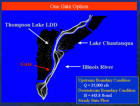
Download Animation
1-spillway.avi (3.6MB)
Two Gates Option:
This animation details flow patterns with two spillways along the levee. With two spillways, a flood conveyance through the drainage district is illustrated.
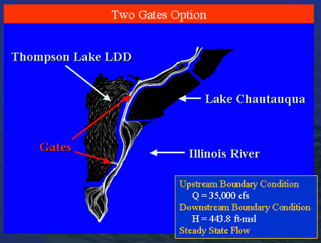
Download Animation
2-spillway.avi (3.5MB)
- Home
- | Data
- | Maps/GIS
- | Models
- | Publications
- | Research
- | Agencies
- | Visualizations
All files and information © 2018 Illinois State Water Survey. Disclaimer.
Email the Web Administrator with questions or comments.