
- Home
 Watersheds
 - Watersheds - Kankakee
Watersheds - Kankakee
Watershed Profile
Name
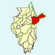
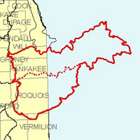
Kankakee
USGS Cataloging Unit
07120001, 07120002 (Iroquois)
Description
The Kankakee watershed in northeastern Illinois and northwestern Indiana is part of the Illinois River basin. Together with its major tributary, the Iroquois, the watershed drains portions of six Illinois counties and has a total area in Illinois of approximately 2,170 square miles. Agriculture is the primary use of land within the watershed.
Web Resources
- Kankakee Watershed web links
- View all of the Kankakee Watershed links in the ILRDSS database.
- The Illinois Streamflow Assessment Model (ILSAM)
- Stream flow estimates for streams located within the Kankakee watershed.
Jump to another watershed
- Home
- | Data
- | Maps/GIS
- | Models
- | Publications
- | Research
- | Agencies
- | Visualizations
All files and information © 2018 Illinois State Water Survey. Disclaimer.
Email the Web Administrator with questions or comments.