
- Home
 Watersheds
 - Watersheds - Cache
Watersheds - Cache
Watershed Profile
Name
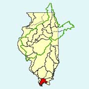
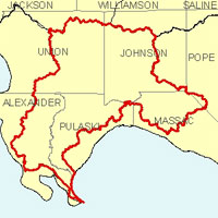
Cache
USGS Cataloging Unit
07140108
Description
The Cache watershed in southern Illinois is part of the Mississippi and Ohio River basins. With drainage from six counties, the watershed has a total area of approximately 740 square miles. The Cache Watershed is the least populated major watershed in Illinois, totaling an estimated 10,914 people. The use of land within the watershed is a diverse mix of agriculture, grasslands, wetlands, and forests.
Web Resources
- Cache Watershed web links
- View all of the Cache Watershed links in the ILRDSS database.
- Cache River at Ullin, IL - Suspended Sediment Data
- As part of its Benchmark Sediment Monitoring Program, the ISWS has been collecting sediment data at Ullin, IL since 1995.
Jump to another watershed
- Home
- | Data
- | Maps/GIS
- | Models
- | Publications
- | Research
- | Agencies
- | Visualizations
All files and information © 2018 Illinois State Water Survey. Disclaimer.
Email the Web Administrator with questions or comments.