
- Home
 Watersheds
 - Watersheds - Macoupin
Watersheds - Macoupin
Watershed Profile
Name
Macoupin
USGS Cataloging Unit
07130012
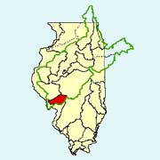
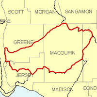
Description
The Macoupin watershed in west-central Illinois is part of the Illinois River basin. With drainage from six counties, the watershed has a total area of approximately 970 square miles. Agriculture is the primary use of land within the watershed.
Web Resources
- Macoupin Watershed web links
- View all of the Macoupin Watershed links in the ILRDSS database.
- Macoupin Watershed Water Data
- The USGS National Water Information System provides real-time and historical data on surface water flow, ground water levels, and water quality of streams in the US.
Jump to another watershed
- Home
- | Data
- | Maps/GIS
- | Models
- | Publications
- | Research
- | Agencies
- | Visualizations
All files and information © 2018 Illinois State Water Survey. Disclaimer.
Email the Web Administrator with questions or comments.