
River - Iroquois
River Profile!
Name
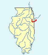
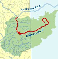
Iroquois
Description
The Iroquois River, a tributary of the Kankakee River, is located in northeastern Illinois and northwestern Indiana. It is 103 miles in length and has a drainage area in Illinois of approximately 1,290 square miles. Its major tributaries include Spring Creek and Sugar Creek. The Iroquois River flows southwest from Indiana to the Iroquois County town of Watseka where it turns and flows in a northerly direction until it drains to the Kankakee River near the town of Aroma Park.
Web Resources
- Iroquois River web links
- View all of the Iroquois River links in the ILRDSS database.
Jump to another river
- Home
- | Data
- | Maps/GIS
- | Models
- | Publications
- | Research
- | Agencies
- | Visualizations
All files and information © 2018 Illinois State Water Survey. Disclaimer.
Email the Web Administrator with questions or comments.