
GIS Visualizations
 Computer animations are a powerful way to visualize complex scientific processes. The GIS scientists at the Illinois State
Water Survey are creating animations to answer specific "what if" questions related to the Illinois
River Basin. By combining existing GIS data and models with 3-D animation software, scientists can better visualize what is happening in the watershed.
Computer animations are a powerful way to visualize complex scientific processes. The GIS scientists at the Illinois State
Water Survey are creating animations to answer specific "what if" questions related to the Illinois
River Basin. By combining existing GIS data and models with 3-D animation software, scientists can better visualize what is happening in the watershed.
Note: To view these animations, you will need software capable of playing WMV files, such as Windows Media Player.
Download instructions: For Windows PCs, right-click on "View Animation", select “Save Target As”, and save the file to your local machine. For Macintosh, CTRL-click the mouse button to open the contextual dialog and select "Save Target As."
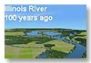
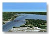
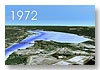
Emiquon Series
This series features a 6-mile portion of the Illinois River beginning south of Havana, IL (Mile 119) and traveling up river to the south end of Chautauqua National Wildlife Refuge (mile 125). It is focused on the west side of the river, an area called Emiquon. Historically the area was occupied by Thompson and Flag Lakes, but those lakes were drained and the area is now cultivated.
 |
|
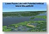
Lower Peoria Lake Series
This series was created to visualize potential constructed islands created from dredged material of Lower Peoria Lake just east of Peoria, IL.
 |
|
 |
|
 |
|
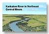
Kankakee River Series
This series features a virtual fly-over of the Kankakee River beginning southwest of Kankakee, and heading north along the river into Indiana.
 |
|
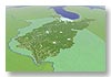
Illinois River Basin Series
This series features fly-over tours of the entire Illinois River Basin.
 |
|
- Home
- | Data
- | Maps/GIS
- | Models
- | Publications
- | Research
- | Agencies
- | Visualizations
All files and information © 2018 Illinois State Water Survey. Disclaimer.
Email the Web Administrator with questions or comments.