
Search Results
Search Results For:
All Maps/GIS
286 links were found.
Displaying Page 8 (of 15)
Page: [<< Prev] 1 | 2 | 3 | 4 | 5 | 6 | 7 | 8 | 9 | 10 | 11 | 12 | 13 | 14 | 15 | [Next >>]
Maps/GIS- 141 Knox County Coal Maps
- ISGS Coal Map Series. Includes mines, resources, and logs.
- 142 Knox County Orthophotography Data 1998-1999
- Illinois National Aerial Photography Program Digital Orthophotography quarter Quadrangle data for Knox County in the Universal Transverse Mercator (UTM) coordinate system with a NAD83 datum.

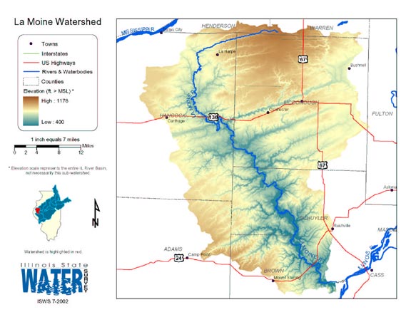
- 143 La Moine Watershed
- Thematic map of the La Moine watershed showing roads, county boundaries, and elevation changes.
- Download Options: LoRes preview | HiRes (2.42 MB) | Metadata
- 144 Lake County Orthophotography Data 1998-1999
- Illinois National Aerial Photography Program Digital Orthophotography quarter Quadrangle data for Lake County in the Universal Transverse Mercator (UTM) coordinate system with a NAD83 datum.
- 145 Land Cover Data for Illinois
- Land cover .TIF images and statistical summaries available for years 1999-2000.
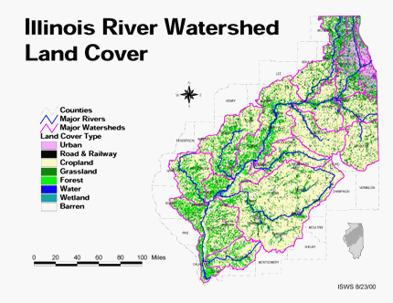
- 146 Land cover in the Illinois River Watershed
- Thematic map showing land cover from raster imagery.
- Download Options: LoRes preview | HiRes (2.68 MB) | Metadata
- 147 LaSalle County Coal Maps
- ISGS Coal Map Series. Includes mines, resources, and logs.
- 148 Lasalle County Orthophotography Data 1998-1999
- Illinois National Aerial Photography Program Digital Orthophotography quarter Quadrangle data for Lasalle County in the Universal Transverse Mercator (UTM) coordinate system with a NAD83 datum.
- 149 Lawrence County Coal Maps
- ISGS Coal Map Series. Includes mines, resources, and logs.
- 150 Lawrence County Orthophotography Data 1998-1999
- Illinois National Aerial Photography Program Digital Orthophotography quarter Quadrangle data for Lawrence County in the Universal Transverse Mercator (UTM) coordinate system with a NAD83 datum.
- 151 Lee County Orthophotography Data 1998-1999
- Illinois National Aerial Photography Program Digital Orthophotography quarter Quadrangle data for Lee County in the Universal Transverse Mercator (UTM) coordinate system with a NAD83 datum.
- 152 Livingston County Coal Maps
- ISGS Coal Map Series. Includes mines, resources, and logs.
- 153 Livingston County Orthophotography Data 1998-1999
- Illinois National Aerial Photography Program Digital Orthophotography quarter Quadrangle data for Livingston County in the Universal Transverse Mercator (UTM) coordinate system with a NAD83 datum.
- 154 Logan County Coal Maps
- ISGS Coal Map Series. Includes mines, resources, and logs.
- 155 Logan County Orthophotography Data 1998-1999
- Illinois National Aerial Photography Program Digital Orthophotography quarter Quadrangle data for Logan County in the Universal Transverse Mercator (UTM) coordinate system with a NAD83 datum.
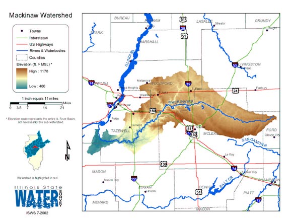
- 156 Mackinaw Watershed Map
- Thematic map of the Mackinaw watershed showing roads, county boundaries, and elevation changes.
- Download Options: LoRes preview | HiRes (2.61 MB) | Metadata
- 157 Macon County Coal Maps
- ISGS Coal Map Series. Includes mines, resources, and logs.
- 158 Macon County Orthophotography Data 1998-1999
- Illinois National Aerial Photography Program Digital Orthophotography quarter Quadrangle data for Macon County in the Universal Transverse Mercator (UTM) coordinate system with a NAD83 datum.
- 159 Macoupin County Coal Maps
- ISGS Coal Map Series. Includes mines, resources, and logs.
- 160 Macoupin County Orthophotography Data 1998-1999
- Illinois National Aerial Photography Program Digital Orthophotography quarter Quadrangle data for Macoupin County in the Universal Transverse Mercator (UTM) coordinate system with a NAD83 datum.
Page: [<< Prev] 1 | 2 | 3 | 4 | 5 | 6 | 7 | 8 | 9 | 10 | 11 | 12 | 13 | 14 | 15 | [Next >>]
- Home
- | Data
- | Maps/GIS
- | Models
- | Publications
- | Research
- | Agencies
- | Visualizations
All files and information © 2018 Illinois State Water Survey. Disclaimer.
Email the Web Administrator with questions or comments.