
Search Results
Search Results For:
All Maps/GIS
286 links were found.
Displaying Page 6 (of 15)
Page: [<< Prev] 1 | 2 | 3 | 4 | 5 | 6 | 7 | 8 | 9 | 10 | 11 | 12 | 13 | 14 | 15 | [Next >>]
Maps/GIS- 101 Hamilton County Coal Maps
- ISGS Coal Map Series. Includes mines, resources, and logs.
- 102 Hamilton County Orthophotography Data 1998-1999
- Illinois National Aerial Photography Program Digital Orthophotography quarter Quadrangle data for Hamilton County in the Universal Transverse Mercator (UTM) coordinate system with a NAD83 datum.

- 103 Hancock County Coal Maps
- ISGS Coal Map Series. Includes mines, resources, and logs.
- 104 Hancock County Orthophotography Data 1998-1999
- Illinois National Aerial Photography Program Digital Orthophotography quarter Quadrangle data for Hancock County in the Universal Transverse Mercator (UTM) coordinate system with a NAD83 datum.
- 105 Hardin County Coal Maps
- ISGS Coal Map Series. Includes mines, resources, and logs.
- 106 Hardin County Orthophotography Data 1998-1999
- Illinois National Aerial Photography Program Digital Orthophotography quarter Quadrangle data for Hardin County in the Universal Transverse Mercator (UTM) coordinate system with a NAD83 datum.
- 107 Henderson County Coal Maps
- ISGS Coal Map Series. Includes mines, resources, and logs.
- 108 Henderson County Orthophotography Data 1998-1999
- Illinois National Aerial Photography Program Digital Orthophotography quarter Quadrangle data for Henderson County in the Universal Transverse Mercator (UTM) coordinate system with a NAD83 datum.
- 109 Henry County Coal Maps
- ISGS Coal Map Series. Includes mines, resources, and logs.
- 110 Henry County Orthophotography Data 1998-1999
- Illinois National Aerial Photography Program Digital Orthophotography quarter Quadrangle data for Henry County in the Universal Transverse Mercator (UTM) coordinate system with a NAD83 datum.
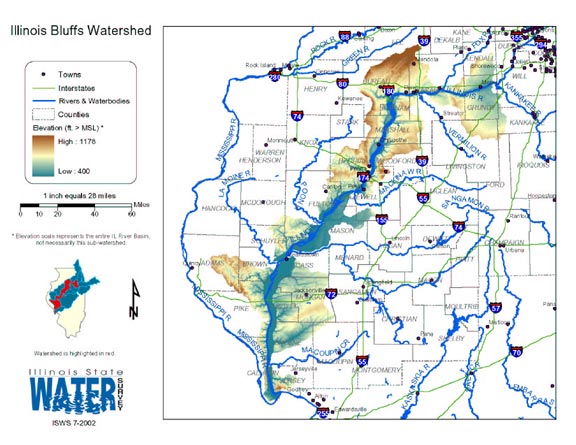
- 111 Illinois Bluffs Watershed
- Thematic map of the Illinois Bluffs watershed showing roads, county boundaries, and elevation changes.
- Download Options: LoRes preview | HiRes (2.26 MB) | Metadata
- 112 Illinois County Boundaries, Polygons and Lines
- GIS data - zipped shapefile
- 113 Illinois Floodplain Maps
- ISWS resource providing preliminary and final maps of Illinois floodplains.
- 114 Illinois Oil and Gas Resources (ILOIL) Internet Map Service
- ISGS interactive map series
- 115 Illinois Public Land Survey System (PLSS) Boundaries
- The polygon attribute data include meridian, township, range, section and county number (FIPS) designations. The line attributes indicate line type, including the state line, county lines, township and range lines, section lines, Indian treaty boundaries, base lines, principal meridians, and boundaries between areas mapped from different principal meridians. (ISGS, 2003).
THESE DATA HAVE POSITIONAL INACCURACY OF UP TO 600 FEET IN SOME AREAS OF THE STATE. THEY ARE NOT TO BE USED AT SCALES GREATER THAN 1:62,500. THE DATA ARE NOT APPROPRIATE AS A GEODETIC, LEGAL OR ENGINEERING BASE.
- 116 Illinois River Basin GIS Data Viewer
- Interactive map provided by the ISWS. Viewable layers include watersheds, rivers, water quality, geology, and groundwater.
- 117 Illinois River Basin Weather Stations
- The weather stations in this data set were gathered from the WDM database within the Basins watershed modeling program. Coordinates for the stations were exported from Basins, then formatted and imported into ArcGIS. This data set was created to support research at the Illinois State Water Survey. (shapefile, .zip archive)
- 118 Illinois River Watershed - Poster
- Poster-sized (26x38) map of the entire Illinois River Watershed. Part of the Illinois State Water Survey published Map Series (2003-1)
- Download Options: LoRes preview | HiRes (3.5 MB) | Metadata
- 119 Illinois State Boundary
- Two versions: one includes the state boundary that extends into Lake Michigan, and one depicts the state boundary as the Lake Michigan shore line. GIS data (shapefile).
- 120 Illinois State Water Survey GIS Services
- A general resource site for GIS activities at the ISWS.
Page: [<< Prev] 1 | 2 | 3 | 4 | 5 | 6 | 7 | 8 | 9 | 10 | 11 | 12 | 13 | 14 | 15 | [Next >>]
- Home
- | Data
- | Maps/GIS
- | Models
- | Publications
- | Research
- | Agencies
- | Visualizations
All files and information © 2018 Illinois State Water Survey. Disclaimer.
Email the Web Administrator with questions or comments.