
Search Results
Search Results For:
All Maps/GIS
286 links were found.
Displaying Page 1 (of 15)
Page: 1 | 2 | 3 | 4 | 5 | 6 | 7 | 8 | 9 | 10 | 11 | 12 | 13 | 14 | 15 | [Next >>]
Maps/GIS- 1 1993 Mississippi River Flood Hazard Mitigation Grant Program
- 1993 Mississippi River flood maps that show properties damaged in the event.
- 2 Adams County Coal Maps
- ISGS Coal Map Series. Includes mines, resources, and logs.
- 3 Adams County Orthophotography Data 1998-1999
- Illinois National Aerial Photography Program Digital Orthophotography quarter Quadrangle data for Adams County in the Universal Transverse Mercator (UTM) coordinate system with a NAD83 datum.

- 4 Alexander County Orthophotography Data 1998-1999
- Illinois National Aerial Photography Program Digital Orthophotography quarter Quadrangle data for Alexander County in the Universal Transverse Mercator (UTM) coordinate system with a NAD83 datum.
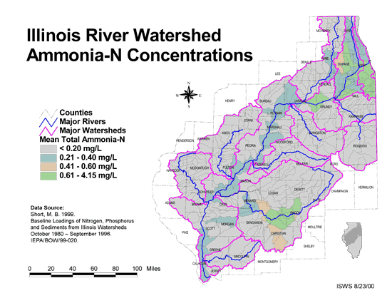
- 5 Ammonia-N Concentrations in the Illinois River Watershed
- Thematic map showing the mean total Ammonia-N for each of the major sub-watersheds.
- Download Options: LoRes preview | HiRes (624 K) | Metadata
- 6 Anticlines, Synclines, and Monoclines
- Structural features, anticlines, synclines, and monoclines in Illinois. Features depicted are limited to significant anticlines, synclines and monoclines. Names of the features and the geologic horizons (bedrock unit) on which they were mapped are included. GIS data (shapefile)
- 7 Archaeological Resource Potential
- Areas in Illinois believed to posses a high archaeologic potential. Data developed by the Illinois State Museum and intended for coarse regional analysis. ISM, 1994. GIS data - zipped shapefile
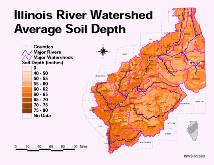
- 8 Average soil depth in the Illinois River Watershed
- Thematic map showing the average soil depth (inches) across the basin.
- Download Options: LoRes preview | HiRes (3.36 MB) | Metadata
- 9 Bedrock Geology - 1967
- Distribution and extent of the bedrock geologic units within Illinois. GIS data (shapefile)
- 10 Bedrock Geology - 2005
- Distribution and extent of the bedrock geologic units within Illinois. GIS data (shapefile)
- 11 Bedrock Topography
- Bedrock topography is shown as 50-foot (15-meter) contours of bedrock elevation above mean sea level (msl). GIS data (shapefile)
- 12 Bedrock Valleys
- Continuous lines representing the lowermost elevations/ locations of (buried) bedrock valleys in the state of Illinois. GIS data (shapefile)
- 13 Bond County Coal Maps
- ISGS Coal Map Series. Includes mines, resources, and logs.
- 14 Bond County Orthophotography Data 1998-1999
- Illinois National Aerial Photography Program Digital Orthophotography quarter Quadrangle data for Bond County in the Universal Transverse Mercator (UTM) coordinate system with a NAD83 datum.
- 15 Boone County Orthophotography Data 1998-1999
- Illinois National Aerial Photography Program Digital Orthophotography quarter Quadrangle data for Boone County in the Universal Transverse Mercator (UTM) coordinate system with a NAD83 datum.
- 16 Brown County Coal Maps
- ISGS Coal Map Series. Includes mines, resources, and logs.
- 17 Brown County Orthophotography Data 1998-1999
- Illinois National Aerial Photography Program Digital Orthophotography quarter Quadrangle data for Brown County in the Universal Transverse Mercator (UTM) coordinate system with a NAD83 datum.
- 18 Bureau County Coal Maps
- ISGS Coal Map Series. Includes mines, resources, and logs.
- 19 Bureau County Orthophotography Data 1998-1999
- Illinois National Aerial Photography Program Digital Orthophotography quarter Quadrangle data for Bureau County in the Universal Transverse Mercator (UTM) coordinate system with a NAD83 datum.
- 20 Calhoun County Coal Maps
- ISGS Coal Map Series. Includes mines, resources, and logs.
Page: 1 | 2 | 3 | 4 | 5 | 6 | 7 | 8 | 9 | 10 | 11 | 12 | 13 | 14 | 15 | [Next >>]
- Home
- | Data
- | Maps/GIS
- | Models
- | Publications
- | Research
- | Agencies
- | Visualizations
All files and information © 2018 Illinois State Water Survey. Disclaimer.
Email the Web Administrator with questions or comments.