
- Home

- Rivers - Mackinaw
- Search Results
Search Results
Search Results For:
River > Mackinaw
49 links were found.
Jump to: Data Online Maps/GIS Publications Agencies/Organizations
Displaying Page 1 (of 3)
Data Online- 1 Flood Discharge Database
- FEMA-published and selected other statistical flood discharge values, searchable by watershed or county.
- 2 Illinois Water Quality
- EPA maintained website with links to all Illinois watershed water quality summary reports dating back to 1996.
- 3 MACKINAW RIVER AT COLFAX, IL - Water Data
- The USGS National Water Information System provides real-time and historical data on surface water flow, ground water levels, and water quality of streams in the US.
- 4 MACKINAW RIVER BELOW CONGERVILLE, IL - Water Data
- The USGS National Water Information System provides real-time and historical data on surface water flow, ground water levels, and water quality of streams in the US.
- 5 MACKINAW RIVER BELOW GREEN VALLEY, IL - Water Data
- The USGS National Water Information System provides real-time and historical data on surface water flow, ground water levels, and water quality of streams in the US.
- 6 MACKINAW RIVER NEAR CONGERVILLE, IL - Water Data
- The USGS National Water Information System provides real-time and historical data on surface water flow, ground water levels, and water quality of streams in the US.
- 7 MACKINAW RIVER NEAR GREEN VALLEY, IL - Water Data
- The USGS National Water Information System provides real-time and historical data on surface water flow, ground water levels, and water quality of streams in the US.
- 8 MACKINAW RIVER NEAR HOPEDALE, IL - Water Data
- The USGS National Water Information System provides real-time and historical data on surface water flow, ground water levels, and water quality of streams in the US.
- 9 MACKINAW RIVER NEAR KAPPA, IL - Water Data
- The USGS National Water Information System provides real-time and historical data on surface water flow, ground water levels, and water quality of streams in the US.
- 10 MACKINAW RIVER NEAR MACKINAW, IL - Water Data
- The USGS National Water Information System provides real-time and historical data on surface water flow, ground water levels, and water quality of streams in the US.
- 11 MACKINAW RIVER NEAR TREMONT, IL - Water Data
- The USGS National Water Information System provides real-time and historical data on surface water flow, ground water levels, and water quality of streams in the US.
- 12 National Weather Service
- Provides weather, water, and climate data, forecasts and warnings.
- 13 Provisional Monthly Flow Data
- This site shows provisional, monthly mean flow data for 26 US Geological Survey gaging stations on rivers and streams throughout Illinois.
- 14 Rivergages.com: Water Levels of Rivers and Lakes
- US Army Corps of Engineers maintained interface to easily access water level data for all Illinois Waterway measurement stations in tabular, graphical, or downloadable form. Divided by watershed.
- 15 Illinois River Basin GIS Data Viewer
- Interactive map provided by the ISWS. Viewable layers include watersheds, rivers, water quality, geology, and groundwater.
- 16 Illinois River Watershed - Poster
- Poster-sized (26x38) map of the entire Illinois River Watershed. Part of the Illinois State Water Survey published Map Series (2003-1)
- Download Options: LoRes preview | HiRes (3.5 MB) | Metadata
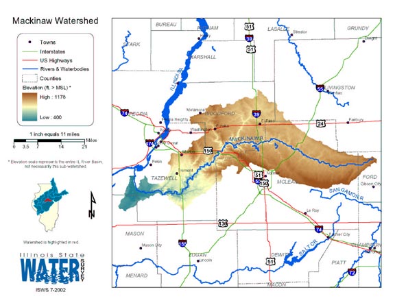
- 17 Mackinaw Watershed Map
- Thematic map of the Mackinaw watershed showing roads, county boundaries, and elevation changes.
- Download Options: LoRes preview | HiRes (2.61 MB) | Metadata
- 18 Resource Management Mapping Service
- Interactive map that allows users to locate, create, and print maps of large and small areas within Illinois. Natural resource, administrative, and economic layers available.
 = Abstract available
  = Full Text available
  = Fact Sheet available
  = PDF format
  = HTML format
  = PowerPoint format
- 19 A technique for evaluating algal growth potential in Illinois surface waters


- Wang, Wun-Cheng, William T. Sullivan, and Ralph L. Evans, 1973 ISWS RI-72
- 20 Adequacy of Illinois surface water supply systems to meet future demands
- McConkey Broeren, Sally, and Krishan P. Singh, 1989 ISWS CR-477
- Home
- | Data
- | Maps/GIS
- | Models
- | Publications
- | Research
- | Agencies
- | Visualizations
All files and information © 2018 Illinois State Water Survey. Disclaimer.
Email the Web Administrator with questions or comments.