
- Home

- Counties - Montgomery
- Search Results
Search Results
Search Results For:
County > Montgomery
97 links were found.
Jump to: Data Online Maps/GIS Publications Research and Programs Agencies/Organizations
Displaying Page 3 (of 5)
Page: [<< Prev] 1 | 2 | 3 | 4 | 5 | [Next >>]
Maps/GIS- 41 Montgomery County Orthophotography Data 1998-1999
- Illinois National Aerial Photography Program Digital Orthophotography quarter Quadrangle data for Montgomery County in the Universal Transverse Mercator (UTM) coordinate system with a NAD83 datum.

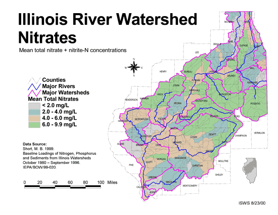
- 42 Nitrates in the Illinois River Watershed (mean total nitrate + nitrite-N concentrations)
- Thematic map showing the mean total nitrate + nitrite-N concentrations for each of the major sub-watersheds.
- Download Options: LoRes preview | HiRes (624 K) | Metadata
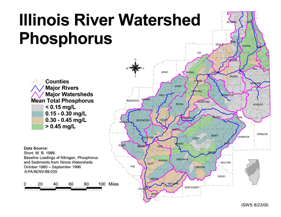
- 43 Phosphorus in the Illinois River Watershed
- Thematic map showing the mean total phosphorus concentrations for each of the major sub-watersheds.
- Download Options: LoRes preview | HiRes (624 K) | Metadata
- 44 Resource Management Mapping Service
- Interactive map that allows users to locate, create, and print maps of large and small areas within Illinois. Natural resource, administrative, and economic layers available.
- 45 Sediment delivery to the main stem of the Illinois River
- Using sediment delivery classes, this map describes sediment delivery to the Illinois River from the major sub-watersheds.
- Download Options: LoRes preview | HiRes (630 K) | Metadata
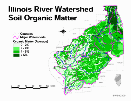
- 46 Soil organic matter in the Illinois River Watershed
- Thematic map showing the percent organic matter for each of the major sub-watersheds.
- Download Options: LoRes preview | HiRes (4.69 MB) | Metadata
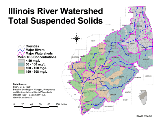
- 47 Total suspended solids in the Illinois River Watershed
- Thematic map showing the mean TSS concentrations for each of the major sub-watersheds.
- Download Options: LoRes preview | HiRes (626 K) | Metadata
- 48 Tributaries in the Illinois River Watershed
- Thematic map showing the tributaries throughout the basin.
- Download Options: LoRes preview | HiRes (1.43 MB) | Metadata
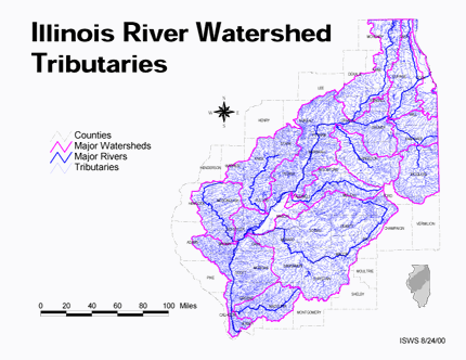
 = Abstract available
  = Full Text available
  = Fact Sheet available
  = PDF format
  = HTML format
  = PowerPoint format
- 49 100 - year rainstorms in the Midwest: design characteristics


- Huff, Floyd A., 1993 ISWS C-176
- 50 7-day 10-year low flows of streams in the Kankakee, Sangamon, Embarras, Little Wabash, and southern regions
- Singh, Krishan P., Ganapathi S. Ramamurthy, and Il Won Seo, 1988 ISWS CR-441
- 51 7-day 10-year low flows of streams in the Rock, Spoon, La Moine, and Kaskaskia regions
- Singh, Krishan P., Ganapathi S. Ramamurthy, and Il Won Seo, 1988 ISWS CR-440
- 52 A summary of information related to the comprehensive management of groundwater and surface water resources in the Sangamon River Basin, Illinois
- O'Hearn, Michael, and Tamara L. Williams, 1982 ISWS CR-299
- 53 Adequacy of Illinois surface water supply systems to meet future demands
- McConkey Broeren, Sally, and Krishan P. Singh, 1989 ISWS CR-477
- 54 Analysis of Nutrients, Selected Inorganic Constituents, and Trace Elements in Water From Illinois Community-supply Wells, 1984-91
- Online USGS report
- Warner, K.L., and A.R. Schmidt, 1999 U.S. Geological Survey Water-Resources Investigations Report 99-4152
- 55 Assessment of a regional aquifer in central Illinois
- Burris, Charles B., Walter J. Morse, and Thomas G. Naymik, 1981 ISWS COOP-6
- 56 Environmentally acceptable morphologic channel design of streams with small to medium-sized drainage areas
- McConkey Broeren, Sally, and Krishan P. Singh, 1990 ISWS CR-495
- 57 Future water demands of public surface water supply systems in Illinois
- Singh, Krishan P., Sally McConkey Broeren, Robin B. King, and Michael L. Pubentz, 1988 ISWS CR-442
- 58 Hydraulic geometry of 12 selected stream systems of the United States
- Stall, John B., and Chih Ted Yang, 1970 ISWS CR-115
- 59 Hydraulic geometry of Illinois streams
- Stall, John B., and Yu-Si Fok, 1968 ISWS CR-92
- 60 Hydrologic Model Development for the Illinois River Basin Using BASINS 3.0
- Demissie, Misganaw, Jaswinder Singh, H. Vernon Knapp, Patricia Saco, Yanqing Lian., 2007 ISWS CR 2007-03
- Home
- | Data
- | Maps/GIS
- | Models
- | Publications
- | Research
- | Agencies
- | Visualizations
All files and information © 2018 Illinois State Water Survey. Disclaimer.
Email the Web Administrator with questions or comments.