
- Home

- Rivers - Sangamon
- Search Results
Search Results
Search Results For:
River > Sangamon
78 links were found.
Jump to: Data Online Maps/GIS Publications Agencies/Organizations
Displaying Page 2 (of 4)
Page: [<< Prev] 1 | 2 | 3 | 4 | [Next >>]
Data Online- 21 SANGAMON RIVER NEAR BOLIVIA, IL - Water Data
- The USGS National Water Information System provides real-time and historical data on surface water flow, ground water levels, and water quality of streams in the US.
- 22 SANGAMON RIVER NEAR BUCKHART, IL - Water Data
- The USGS National Water Information System provides real-time and historical data on surface water flow, ground water levels, and water quality of streams in the US.
- 23 SANGAMON RIVER NEAR CHANDLERVILLE, IL - Water Data
- The USGS National Water Information System provides real-time and historical data on surface water flow, ground water levels, and water quality of streams in the US.
- 24 SANGAMON RIVER NEAR CISCO, IL - Water Data
- The USGS National Water Information System provides real-time and historical data on surface water flow, ground water levels, and water quality of streams in the US.
- 25 SANGAMON RIVER NEAR DAWSON, IL - Water Data
- The USGS National Water Information System provides real-time and historical data on surface water flow, ground water levels, and water quality of streams in the US.
- 26 SANGAMON RIVER NEAR FISHER, IL - Water Data
- The USGS National Water Information System provides real-time and historical data on surface water flow, ground water levels, and water quality of streams in the US.
- 27 SANGAMON RIVER NEAR MAHOMET, IL - Water Data
- The USGS National Water Information System provides real-time and historical data on surface water flow, ground water levels, and water quality of streams in the US.
- 28 SANGAMON RIVER NEAR MOUNT AUBURN, IL - Water Data
- The USGS National Water Information System provides real-time and historical data on surface water flow, ground water levels, and water quality of streams in the US.
- 29 SANGAMON RIVER NEAR NIANTIC, IL - Water Data
- The USGS National Water Information System provides real-time and historical data on surface water flow, ground water levels, and water quality of streams in the US.
- 30 SANGAMON RIVER NEAR OAKFORD, IL - Water Data
- The USGS National Water Information System provides real-time and historical data on surface water flow, ground water levels, and water quality of streams in the US.
- 31 SANGAMON RIVER NEAR OAKLEY, IL - Water Data
- The USGS National Water Information System provides real-time and historical data on surface water flow, ground water levels, and water quality of streams in the US.
- 32 SANGAMON RIVER NEAR WYCKLES CORNER, IL - Water Data
- The USGS National Water Information System provides real-time and historical data on surface water flow, ground water levels, and water quality of streams in the US.
- 33 Sangamon River Stage Data and Forecasts
- Data provided by the National Weather Services Advanced Hydrologic Prediction Service
- 34 Illinois River Basin GIS Data Viewer
- Interactive map provided by the ISWS. Viewable layers include watersheds, rivers, water quality, geology, and groundwater.
- 35 Illinois River Watershed - Poster
- Poster-sized (26x38) map of the entire Illinois River Watershed. Part of the Illinois State Water Survey published Map Series (2003-1)
- Download Options: LoRes preview | HiRes (3.5 MB) | Metadata
- 36 Resource Management Mapping Service
- Interactive map that allows users to locate, create, and print maps of large and small areas within Illinois. Natural resource, administrative, and economic layers available.
- 37 Sangamon Watershed map
- Thematic map of the Sangamon watershed showing roads, county boundaries, and elevation changes.
- Download Options: LoRes preview | HiRes (2.50 MB) | Metadata
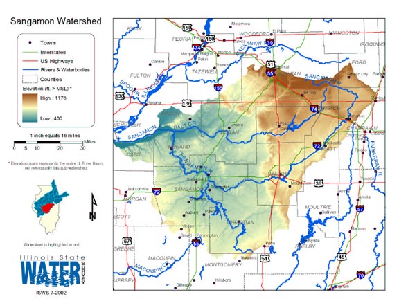
 = Abstract available
  = Full Text available
  = Fact Sheet available
  = PDF format
  = HTML format
  = PowerPoint format
- 38 50 Years of Change in Illinois Hill Prairies


- This publication discusses the history of Illinois hill prairies.
- Robertson, K., M. W. Schwartz, J. W. Olson, B. K. Dunphy, and H. D. Clarke, 1995 Illinois Native Plant Society
- 39 Adequacy of Illinois surface water supply systems to meet future demands

- McConkey Broeren, Sally, and Krishan P. Singh, 1989 ISWS CR-477
- 40 Algae in selected Illinois streams, 1971-1976
- Lin, Shundar, Ralph L. Evans, and Davis B. Beuscher, 1978 ISWS RI-86
- Home
- | Data
- | Maps/GIS
- | Models
- | Publications
- | Research
- | Agencies
- | Visualizations
All files and information © 2018 Illinois State Water Survey. Disclaimer.
Email the Web Administrator with questions or comments.