
- Home

- Counties - Menard
- Search Results
Search Results
Search Results For:
County > Menard
82 links were found.
Jump to: Data Online Maps/GIS Publications Research and Programs Agencies/Organizations
Displaying Page 1 (of 5)
Page: 1 | 2 | 3 | 4 | 5 | [Next >>]
Data Online- 1 7-Day 10-Year Low Flow Maps
- These maps provide information on low flow conditions that might be expected to occur only during droughts (once in 10 years), and associated effluent discharges, water withdrawals, and flow regulations for most Illinois rivers and streams.
- 2 Flood Discharge Database
- FEMA-published and selected other statistical flood discharge values, searchable by watershed or county.
- 3 Illinois Water Quality
- EPA maintained website with links to all Illinois watershed water quality summary reports dating back to 1996.
- 4 Lower Illinois River Basin Aerial Photographs
- Photo mosaics, close-ups, and oblique angle photos of river features.
- 5 Lower Illinois River Basin: Sediment and Discharge
- Graphic depicting sediment and discharge levels throughout the Lower Illinois River channel.
- 6 Lower Sangamon Watershed Profile
- Environmental Protection Agency website containing numerous links to environmental data about the Lower Sangamon watershed.
- 7 Lower Sangamon Watershed Resource Links
- USGS maintained site with links to data, projects, and publications on HUC watersheds
- 8 Lower Sangamon Watershed Water Data
- The USGS National Water Information System provides real-time and historical data on surface water flow, ground water levels, and water quality of streams in the US.
- 9 Menard County Water Data
- The USGS National Water Information System provides real-time and historical data on surface water flow, ground water levels, and water quality of streams in the US.
- 10 National Weather Service: River Watch, Mississippi River Basin
- Illinois River 5-day stage forecasts for three main river segments: Morris to LaSalle, Henry to Beardstown, and New LaGrange to Hardin. Includes links to Upper Mississippi Basin stage forecasts.
- 11 NAWQA Data Warehouse
- Searchable database of National Water Quality Assessment data.
- 12 Salt Watershed Profile
- Environmental Protection Agency website containing numerous links to environmental data about the Salt watershed.
- 13 Salt Watershed Resource Links
- USGS maintained site with links to data, projects, and publications on HUC watersheds
- 14 Salt Watershed Water Data
- The USGS National Water Information System provides real-time and historical data on surface water flow, ground water levels, and water quality of streams in the US.
- 15 SANGAMON RIVER AT PETERSBURG, IL - Water Data
- The USGS National Water Information System provides real-time and historical data on surface water flow, ground water levels, and water quality of streams in the US.
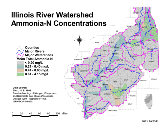
- 16 Ammonia-N Concentrations in the Illinois River Watershed
- Thematic map showing the mean total Ammonia-N for each of the major sub-watersheds.
- Download Options: LoRes preview | HiRes (624 K) | Metadata
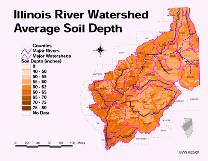
- 17 Average soil depth in the Illinois River Watershed
- Thematic map showing the average soil depth (inches) across the basin.
- Download Options: LoRes preview | HiRes (3.36 MB) | Metadata
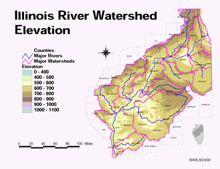
- 18 Elevation in the Illinois River Watershed
- Thematic map showing elevation changes in the basin.
- Download Options: LoRes preview | HiRes (1.76 MB) | Metadata
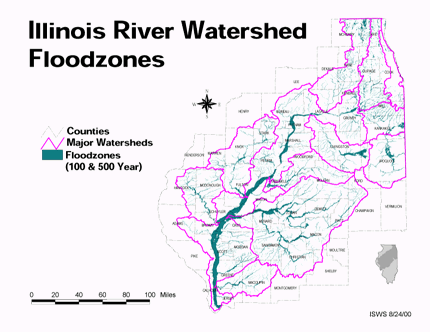
- 19 Floodzones in the Illinois River Watershed
- Thematic map showing the 100 and 500 year floodzones across the basin as of 1986.
- Download Options: LoRes preview | HiRes (3.77 MB) | Metadata
- 20 Illinois County Boundaries, Polygons and Lines
- GIS data - zipped shapefile

- Home
- | Data
- | Maps/GIS
- | Models
- | Publications
- | Research
- | Agencies
- | Visualizations
All files and information © 2018 Illinois State Water Survey. Disclaimer.
Email the Web Administrator with questions or comments.