
- Home

- Counties - Henry
- Search Results
Search Results
Search Results For:
County > Henry
88 links were found.
Jump to: Data Online Maps/GIS Publications Research and Programs Agencies/Organizations Visualizations/Video
Displaying Page 3 (of 5)
Page: [<< Prev] 1 | 2 | 3 | 4 | 5 | [Next >>]
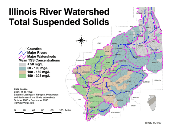
Maps/GIS- 41 Total suspended solids in the Illinois River Watershed
- Thematic map showing the mean TSS concentrations for each of the major sub-watersheds.
- Download Options: LoRes preview | HiRes (626 K) | Metadata
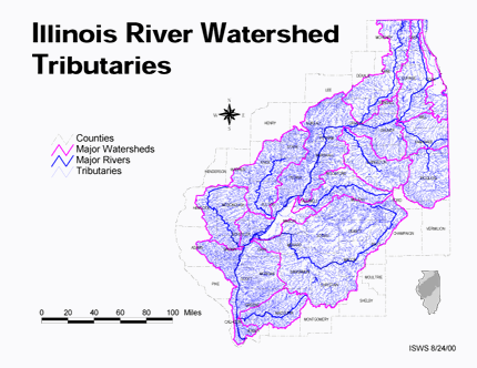
- 42 Tributaries in the Illinois River Watershed
- Thematic map showing the tributaries throughout the basin.
- Download Options: LoRes preview | HiRes (1.43 MB) | Metadata
 = Abstract available
  = Full Text available
  = Fact Sheet available
  = PDF format
  = HTML format
  = PowerPoint format
- 43 100 - year rainstorms in the Midwest: design characteristics


- Huff, Floyd A., 1993 ISWS C-176
- 44 7-day 10-year low flows of streams in the Rock, Spoon, La Moine, and Kaskaskia regions
- Singh, Krishan P., Ganapathi S. Ramamurthy, and Il Won Seo, 1988 ISWS CR-440
- 45 Adequacy of Illinois surface water supply systems to meet future demands
- McConkey Broeren, Sally, and Krishan P. Singh, 1989 ISWS CR-477
- 46 Analysis of Nutrients, Selected Inorganic Constituents, and Trace Elements in Water From Illinois Community-supply Wells, 1984-91
- Online USGS report
- Warner, K.L., and A.R. Schmidt, 1999 U.S. Geological Survey Water-Resources Investigations Report 99-4152
- 47 Diagnostic-feasibility study of Johnson Sauk Trail Lake
- Kothandaraman, Veerasamy, and Ralph L. Evans, 1983 ISWS CR-312
- 48 Geology, hydrology, and water quality of the Cambrian and Ordovician systems in northern Illinois
- Visocky, Adrian P., Marvin G. Sherrill, and Keros Cartwright, 1985 ISWS COOP-10
- 49 Groundwater conditions of the principal aquifers of Lee, Whiteside, Bureau, and Henry counties, Illinois.
- Burch, Stephen L., 2004 ISWS DCS 2004-01
- 50 Hydraulic geometry of Illinois streams
- Stall, John B., and Yu-Si Fok, 1968 ISWS CR-92
- 51 Hydrologic and hydraulic analyses of the Hennepin Canal from Lock 27 to the Rock River
- Demissie, Misganaw, and Nani G. Bhowmik, 1983 ISWS CR-335
- 52 Hydrologic Model Development for the Illinois River Basin Using BASINS 3.0
- Demissie, Misganaw, Jaswinder Singh, H. Vernon Knapp, Patricia Saco, Yanqing Lian., 2007 ISWS CR 2007-03
- 53 Hydrometeorology of heavy rainstorms in selected Illinois basins
- Huff, Floyd A., 1981 ISWS RI-96
- 54 Identification of Unmapped Special Flood Hazard Areas in Illinois
- Graff, Philip, Chap, Laura, McConkey, Sally, DePue, Michael, Allan, Kingsley, Bicksler, Rebecca, 2008 ISWS CR 2008-05
- 55 Illinois River Basin Restoration Comprehensive Plan - Final Draft
- US Army Corps of Engineers, 2007
- 56 Illinois River Watershed Restoration Act (20 ILCS 3967/)

- Entire text of 20 ILCS 3967/ of the Illinois Compiled Statutes
- Illinois General Assembly, 1997
- 57 Illinois Rivers Decision Support System
- Publication describing the motivation and initial planning for the ILRDSS.
- Demissie, Misganaw, Yiping Guo, H. Vernon Knapp, and Nani G. Bhowmik, 1999 ISWS Contract Report 648
- 58 Illinois Rivers Decision Support System (ILRDSS)
- Publication describing the progress and future plans of the ILRDSS.
- 2002 ISWS IEM 2002-02
- 59 Impact of the 1993 flood on sedimentation and sediment quality in backwater lakes of Illinois
- Demissie, Misganaw, 1996 ISWS CR-593
- 60 Initial Assessment: Illinois River Basin Restoration
- Report detailing the U.S. Army Corps of Engineers initial assessment of Illinois River Basin Restoration under Section 519 of the Water Resources Development Act (WRDA) of 2000
- U.S. Army Corps of Engineers, 2002 CEMVR-PM-M
- Home
- | Data
- | Maps/GIS
- | Models
- | Publications
- | Research
- | Agencies
- | Visualizations
All files and information © 2018 Illinois State Water Survey. Disclaimer.
Email the Web Administrator with questions or comments.