
- Home

- Counties - Will
- Search Results
Search Results
Search Results For:
County > Will
205 links were found.
Jump to: Data Online Maps/GIS Publications Research and Programs Agencies/Organizations Visualizations/Video
Displaying Page 2 (of 11)
Page: [<< Prev] 1 | 2 | 3 | 4 | 5 | 6 | 7 | 8 | 9 | 10 | 11 | [Next >>]
Data Online- 21 Illinois Water Quality
- EPA maintained website with links to all Illinois watershed water quality summary reports dating back to 1996.
- 22 Instantaneous Suspended Sediment Data
- The Benchmark Sediment Monitoring Program offers weekly data from suspended sediment samples collected at fifteen sampling sites throughout Illinois. Available in HTML and .csv formats.
- 23 KANKAKEE RIVER AT CUSTER PARK, IL - Water Data
- The USGS National Water Information System provides real-time and historical data on surface water flow, ground water levels, and water quality of streams in the US.
- 24 KANKAKEE RIVER NEAR WILMINGTON, IL - Water Data
- The USGS National Water Information System provides real-time and historical data on surface water flow, ground water levels, and water quality of streams in the US.
- 25 Kankakee Watershed Profile
- Environmental Protection Agency website containing numerous links to environmental data about the Kankakee watershed.
- 26 Kankakee Watershed Resource Links
- USGS maintained site with links to data, projects, and publications on HUC watersheds
- 27 Kankakee Watershed Water Data
- The USGS National Water Information System provides real-time and historical data on surface water flow, ground water levels, and water quality of streams in the US.
- 28 Lower Illinois River Basin Aerial Photographs
- Photo mosaics, close-ups, and oblique angle photos of river features.
- 29 Lower Illinois River Basin: Sediment and Discharge
- Graphic depicting sediment and discharge levels throughout the Lower Illinois River channel.
- 30 Monthly Climate Data- Channahon, IL
- Monthly precipitation and temperature data provided by the State Climatologist. Data available from 1943-present.
- 31 Monthly Climate Data- Joliet, IL
- Monthly precipitation and temperature data provided by the State Climatologist. Data available from 1948-present.
- 32 Monthly Climate Data- Peotone, IL
- Monthly precipitation and temperature data provided by the State Climatologist. Data available from 1940-present.
- 33 National Weather Service: River Watch, Mississippi River Basin
- Illinois River 5-day stage forecasts for three main river segments: Morris to LaSalle, Henry to Beardstown, and New LaGrange to Hardin. Includes links to Upper Mississippi Basin stage forecasts.
- 34 NAWQA Data Warehouse
- Searchable database of National Water Quality Assessment data.
- 35 Upper Illinois Watershed Profile
- Environmental Protection Agency website containing numerous links to environmental data about the Upper Illinois watershed.
- 36 Upper Illinois Watershed Resource Links
- USGS maintained site with links to data, projects, and publications on HUC watersheds
- 37 Upper Illinois Watershed Water Data
- The USGS National Water Information System provides real-time and historical data on surface water flow, ground water levels, and water quality of streams in the US.
- 38 Will County Water Data
- The USGS National Water Information System provides real-time and historical data on surface water flow, ground water levels, and water quality of streams in the US.
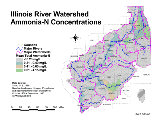
- 39 Ammonia-N Concentrations in the Illinois River Watershed
- Thematic map showing the mean total Ammonia-N for each of the major sub-watersheds.
- Download Options: LoRes preview | HiRes (624 K) | Metadata
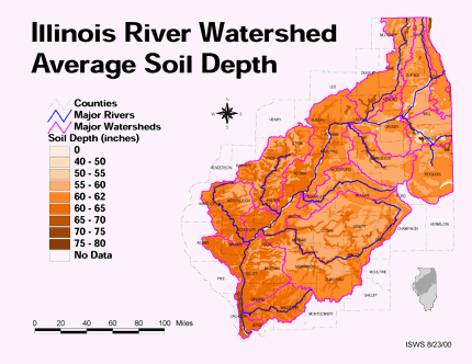
- 40 Average soil depth in the Illinois River Watershed
- Thematic map showing the average soil depth (inches) across the basin.
- Download Options: LoRes preview | HiRes (3.36 MB) | Metadata
Page: [<< Prev] 1 | 2 | 3 | 4 | 5 | 6 | 7 | 8 | 9 | 10 | 11 | [Next >>]
- Home
- | Data
- | Maps/GIS
- | Models
- | Publications
- | Research
- | Agencies
- | Visualizations
All files and information © 2018 Illinois State Water Survey. Disclaimer.
Email the Web Administrator with questions or comments.