
- Home

- Counties - Lee
- Search Results
Search Results
Search Results For:
County > Lee
152 links were found.
Jump to: Data Online Maps/GIS Publications Research and Programs Agencies/Organizations
Displaying Page 4 (of 8)
Page: [<< Prev] 1 | 2 | 3 | 4 | 5 | 6 | 7 | 8 | [Next >>]
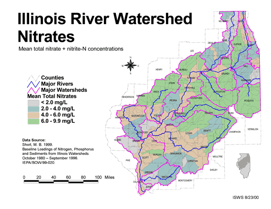
Maps/GIS- 61 Nitrates in the Illinois River Watershed (mean total nitrate + nitrite-N concentrations)
- Thematic map showing the mean total nitrate + nitrite-N concentrations for each of the major sub-watersheds.
- Download Options: LoRes preview | HiRes (624 K) | Metadata
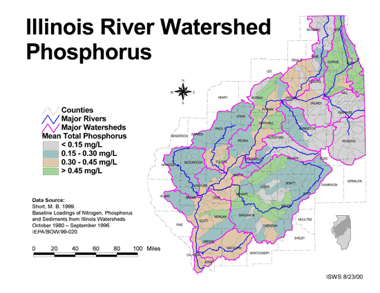
- 62 Phosphorus in the Illinois River Watershed
- Thematic map showing the mean total phosphorus concentrations for each of the major sub-watersheds.
- Download Options: LoRes preview | HiRes (624 K) | Metadata
- 63 Resource Management Mapping Service
- Interactive map that allows users to locate, create, and print maps of large and small areas within Illinois. Natural resource, administrative, and economic layers available.
- 64 Sediment delivery to the main stem of the Illinois River
- Using sediment delivery classes, this map describes sediment delivery to the Illinois River from the major sub-watersheds.
- Download Options: LoRes preview | HiRes (630 K) | Metadata
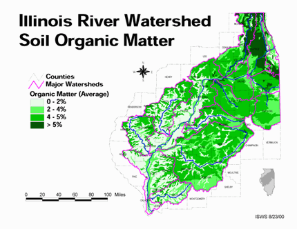
- 65 Soil organic matter in the Illinois River Watershed
- Thematic map showing the percent organic matter for each of the major sub-watersheds.
- Download Options: LoRes preview | HiRes (4.69 MB) | Metadata
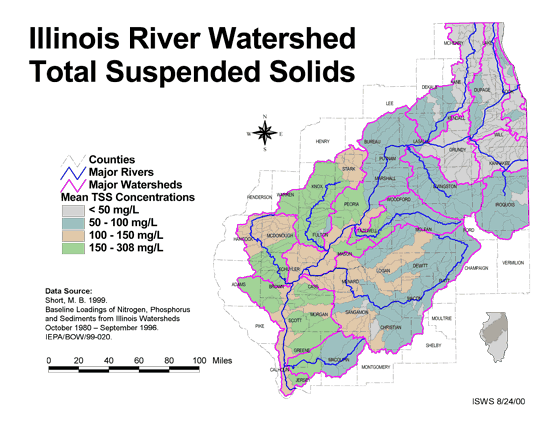
- 66 Total suspended solids in the Illinois River Watershed
- Thematic map showing the mean TSS concentrations for each of the major sub-watersheds.
- Download Options: LoRes preview | HiRes (626 K) | Metadata
- 67 Tributaries in the Illinois River Watershed
- Thematic map showing the tributaries throughout the basin.
- Download Options: LoRes preview | HiRes (1.43 MB) | Metadata
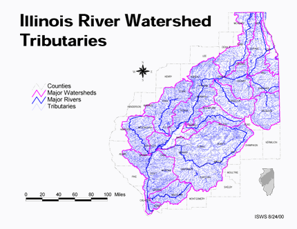
 = Abstract available
  = Full Text available
  = Fact Sheet available
  = PDF format
  = HTML format
  = PowerPoint format
- 68 7-day 10-year low flows of streams in northeastern Illinois


- Singh, Krishan P., 1983 ISWS CR-307
- 69 7-day 10-year low flows of streams in the Rock, Spoon, La Moine, and Kaskaskia regions
- Singh, Krishan P., Ganapathi S. Ramamurthy, and Il Won Seo, 1988 ISWS CR-440
- 70 A Comparison of Potentiometric Surfaces for the Cambrian-Ordovician Aquifers of Northeastern Illinois, 2000 and 2007
- Burch, Stephen L., 2008 ISWS DCS 2008-04
- 71 Adequacy of Illinois surface water supply systems to meet future demands
- McConkey Broeren, Sally, and Krishan P. Singh, 1989 ISWS CR-477
- 72 Aeration characteristics of flow release controls on Illinois Waterway dams
- Butts, Thomes A., and Ralph L. Evans, 1980 ISWS CR-233
- 73 An inventory and evaluation of biological investigations that relate to stream-water quality in the upper Illinois River Basin of Illinois, Indiana, and Wisconsin


- Online USGS report abstract
- Steffeck, D.W., and R.G. Striegl, 1989 U.S. Geological Survey Water-Resources Investigations Report 89-4041
- 74 Analysis of Nutrients, Selected Inorganic Constituents, and Trace Elements in Water From Illinois Community-supply Wells, 1984-91
- Online USGS report
- Warner, K.L., and A.R. Schmidt, 1999 U.S. Geological Survey Water-Resources Investigations Report 99-4152
- 75 Aquatic Resources Monitoring in the Upper Mississippi River Basin
- Report describing two long-term monitoring projects in the Upper Mississippi River Basin: the Long Term Resource Monitoring Project (LTRMP) and the Long Term Illinois River Fish Population Monitoring Project, also known as the Long Term Electrofishing project (LTEF).
- Pegg, Mark A., 2002 Illinois Natural History Survey Reports Spring 2002
- 76 Availability and suitability of municipal wastewater information for use in a national water-quality assessment: A case study of the upper Illinois River Basin in Illinois, Indiana, and Wisconsin
- Online abstract of US Geological Survey Open-File Report 90-375
- Zogorski, J.S., S.F. Blanchard, R.D. Romack, and F.A. Fitzpatrick., 1990 U.S. Geological Survey Open-File Report 90-375
- 77 CMAP Water Resources Planning
- Chicago Metropolitan Agency for Planning (CMAP) water resources planning website.
- Northeastern Illinois Planning Commission (NIPC), 2000 Short report detailing all water quality activites within the six-county metropolitian Chicago area.
- 78 Creating a Multi-state Database from Well Construction Records: Illinois, Indiana, and Wisconsin
- Online USGS conference proceeding abstract
- Arnold, T.L. and K.L. Warner, 2001 2001 Assoc of Ground Water Scientists and Engineers Annual Meeting and Conference
- 79 Effects of Land Use on Recharge Potential of Surficial and Shallow Bedrock Aquifers in the Upper Illinois River Basin
- Online USGS report
- Arnold, T.L., and M.J. Friedel, 2000 U.S. Geological Survey Water-Resources Investigations Report 00-4027
- 80 Environmental Setting of the Upper Illinois River Basin and Implications for Water Quality
- Online report published by the US Geological Survey
- Arnold, T.L., D.J. Sullivan, M.A. Harris, F.A. Fitzpatrick, B.C. Scudder, P.M. Ruhl, D.W. Hanchar, and J.S. Stewart, 1999 U.S. Geological Survey Water-Resources Investigations Report 98-4268
- Home
- | Data
- | Maps/GIS
- | Models
- | Publications
- | Research
- | Agencies
- | Visualizations
All files and information © 2018 Illinois State Water Survey. Disclaimer.
Email the Web Administrator with questions or comments.