
- Home

- Counties - Cook
- Search Results
Search Results
Search Results For:
County > Cook
267 links were found.
Jump to: Data Online Maps/GIS Publications Research and Programs Agencies/Organizations Visualizations/Video
Displaying Page 5 (of 14)
Page: [<< Prev] 1 | 2 | 3 | 4 | 5 | 6 | 7 | 8 | 9 | 10 | 11 | 12 | 13 | 14 | [Next >>]
Maps/GIS- 81 Illinois River Watershed - Poster
- Poster-sized (26x38) map of the entire Illinois River Watershed. Part of the Illinois State Water Survey published Map Series (2003-1)
- Download Options: LoRes preview | HiRes (3.5 MB) | Metadata
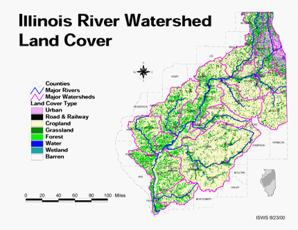
- 82 Land cover in the Illinois River Watershed
- Thematic map showing land cover from raster imagery.
- Download Options: LoRes preview | HiRes (2.68 MB) | Metadata
- 83 Major Watersheds of Illinois
- Poster-sized (26x38) map of the major watersheds in Illinois. Part of the Illinois State Water Survey published Map Series (2000-01)
- Download Options: LoRes preview | HiRes (730 K) | Metadata
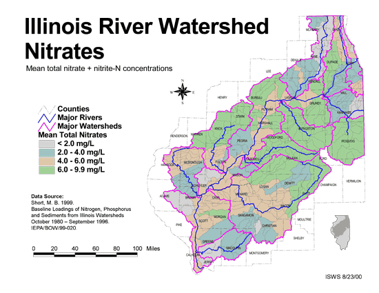
- 84 Nitrates in the Illinois River Watershed (mean total nitrate + nitrite-N concentrations)
- Thematic map showing the mean total nitrate + nitrite-N concentrations for each of the major sub-watersheds.
- Download Options: LoRes preview | HiRes (624 K) | Metadata
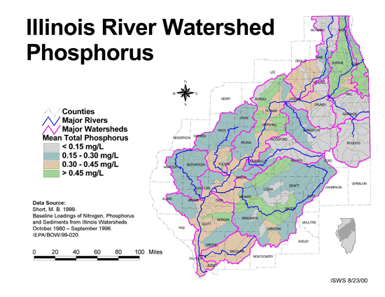
- 85 Phosphorus in the Illinois River Watershed
- Thematic map showing the mean total phosphorus concentrations for each of the major sub-watersheds.
- Download Options: LoRes preview | HiRes (624 K) | Metadata
- 86 Resource Management Mapping Service
- Interactive map that allows users to locate, create, and print maps of large and small areas within Illinois. Natural resource, administrative, and economic layers available.
- 87 Sediment delivery to the main stem of the Illinois River
- Using sediment delivery classes, this map describes sediment delivery to the Illinois River from the major sub-watersheds.
- Download Options: LoRes preview | HiRes (630 K) | Metadata
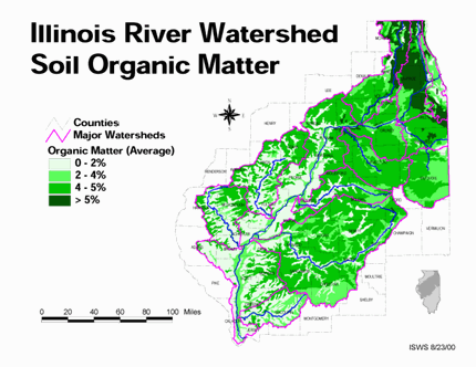
- 88 Soil organic matter in the Illinois River Watershed
- Thematic map showing the percent organic matter for each of the major sub-watersheds.
- Download Options: LoRes preview | HiRes (4.69 MB) | Metadata
- 89 Total suspended solids in the Illinois River Watershed
- Thematic map showing the mean TSS concentrations for each of the major sub-watersheds.
- Download Options: LoRes preview | HiRes (626 K) | Metadata
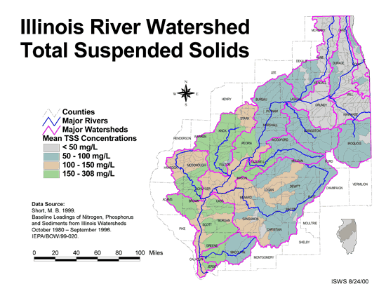
- 90 Tributaries in the Illinois River Watershed
- Thematic map showing the tributaries throughout the basin.
- Download Options: LoRes preview | HiRes (1.43 MB) | Metadata
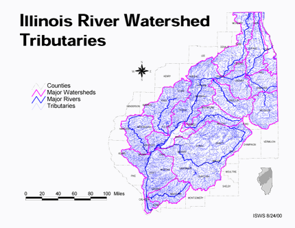
 = Abstract available
  = Full Text available
  = Fact Sheet available
  = PDF format
  = HTML format
  = PowerPoint format
- 91 7-day 10-year low flows of streams in northeastern Illinois


- Singh, Krishan P., 1983 ISWS CR-307
- 92 A Comparison of Potentiometric Surfaces for the Cambrian-Ordovician Aquifers of Northeastern Illinois, 2000 and 2007
- Burch, Stephen L., 2008 ISWS DCS 2008-04
- 93 A preliminary 'least cost' study of future groundwater development in northeastern Illinois
- Moench, Allen F., and Adrian P. Visocky, 1971 ISWS C-102
- 94 A Summary of Pumpage from the Cambrian-Ordovician Aquifers of Northeastern Illinois, 2000-2004
- Burch, Stephen L., H. Allen Wehrmann., 2007 ISWS DCS 2007-03
- 95 Adequacy and economics of water supply in northeastern Illinois, 1985-2010
- Singh, Krishan P., and J. Rodger Adams, 1980 ISWS RI-97
- 96 Adequacy and economics of water supply in northeastern Illinois: proposed groundwater and regional surface water systems, 1985-2010
- Singh, Krishan P., and J. Rodger Adams, 1980 ISWS CR-229
- 97 Adequacy of Illinois surface water supply systems to meet future demands
- McConkey Broeren, Sally, and Krishan P. Singh, 1989 ISWS CR-477
- 98 Algae in selected Illinois streams, 1971-1976
- Lin, Shundar, Ralph L. Evans, and Davis B. Beuscher, 1978 ISWS RI-86
- 99 An assessment of benthic sediments and an inventory of sewer outfalls and land use for selected Chicago areas streams
- Hill, Thomas E., and Thomas A. Butts, 1986 ISWS CR-399
- 100 An assessment of the hydrology and water quality of Indian Ridge Marsh and the potential effects of wetland rehabilitation on the diversity of wetland plant communities
- Roadcap, George S., M.B. Wentzel, Shun D. Lin, E.E. Herricks, Raman K. Raman, Randall A. Locke, and David L. Hullinger, 1999 ISWS CR-654
Page: [<< Prev] 1 | 2 | 3 | 4 | 5 | 6 | 7 | 8 | 9 | 10 | 11 | 12 | 13 | 14 | [Next >>]
- Home
- | Data
- | Maps/GIS
- | Models
- | Publications
- | Research
- | Agencies
- | Visualizations
All files and information © 2018 Illinois State Water Survey. Disclaimer.
Email the Web Administrator with questions or comments.