
- Home

- Watersheds - Spoon
- Search Results
Search Results
Search Results For:
Watershed > Spoon
202 links were found.
Jump to: Data Online Maps/GIS Models Publications Research and Programs Agencies/Organizations Visualizations/Video
Displaying Page 5 (of 11)
Page: [<< Prev] 1 | 2 | 3 | 4 | 5 | 6 | 7 | 8 | 9 | 10 | 11 | [Next >>]
Maps/GIS- 81 Stark County Coal Maps
- ISGS Coal Map Series. Includes mines, resources, and logs.
- 82 Stark County Orthophotography Data 1998-1999
- Illinois National Aerial Photography Program Digital Orthophotography quarter Quadrangle data for Stark County in the Universal Transverse Mercator (UTM) coordinate system with a NAD83 datum.

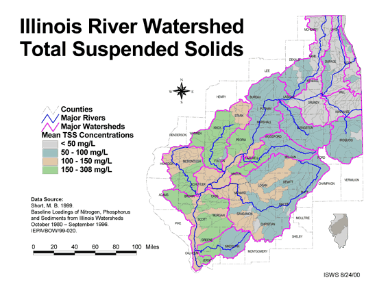
- 83 Total suspended solids in the Illinois River Watershed
- Thematic map showing the mean TSS concentrations for each of the major sub-watersheds.
- Download Options: LoRes preview | HiRes (626 K) | Metadata
- 84 Warren County Coal Maps
- ISGS Coal Map Series. Includes mines, resources, and logs.
- 85 Warren County Orthophotography Data 1998-1999
- Illinois National Aerial Photography Program Digital Orthophotography quarter Quadrangle data for Warren County in the Universal Transverse Mercator (UTM) coordinate system with a NAD83 datum.
- 86 Watershed Models
- Links to simple overviews of various landscape/watershed simulation models. Site maintained by the Environmental Protection Agency.
 = Abstract available
  = Full Text available
  = Fact Sheet available
  = PDF format
  = HTML format
  = PowerPoint format
- 87 100 - year rainstorms in the Midwest: design characteristics


- Huff, Floyd A., 1993 ISWS C-176
- 88 7-day 10-year low flows of streams in the Rock, Spoon, La Moine, and Kaskaskia regions
- Singh, Krishan P., Ganapathi S. Ramamurthy, and Il Won Seo, 1988 ISWS CR-440
- 89 Adequacy of Illinois surface water supply systems to meet future demands
- McConkey Broeren, Sally, and Krishan P. Singh, 1989 ISWS CR-477
- 90 An inventory of Court Creek Watershed characteristics that may relate to water quality in the watershed: Appendices
- Roseboom, Donald P., Ralph L. Evans, John Erickson, and Lyle G. Brooks, 1982 ISWS CR-322a
- 91 An inventory of Court Creek Watershed characteristics that may relate to water quality in the watershed
- Roseboom, Donald, Ralph L. Evans, John Erickson, and Lyle G. Brooks, 1982 ISWS CR-322
- 92 Analysis of Nutrients, Selected Inorganic Constituents, and Trace Elements in Water From Illinois Community-supply Wells, 1984-91
- Online USGS report
- Warner, K.L., and A.R. Schmidt, 1999 U.S. Geological Survey Water-Resources Investigations Report 99-4152
- 93 Benchmark sediment monitoring program for Illinois streams : data report for water years 1994 and 1995.
- Allgire, Richard L., 2001 ISWS DCS 2001-01
- 94 Benchmark sediment monitoring program for Illinois streams : data report for Water Years 1996 and 1997.
- Allgire, Richard L., 2001 ISWS DCS 2001-02
- 95 Benchmark sediment monitoring program for Illinois streams : data report for Water Years 1998 and 1999
- Allgire, Richard L., 2002 ISWS DCS 2002-01
- 96 Benchmark sediment monitoring program for Illinois streams: program summary and site descriptions.
- Allgire, Richard L., and Misganaw Demissie, 1995 ISWS C-181
- 97 Determination of stream width and elevation at selected gaging stations in Illinois for Soil Conservation Service wetland mapping
- Ramamurthy, Ganapathi S., Ming T. Lee, and Krishan P. Singh, 1989 ISWS CR-462
- 98 Evaluation of hydraulic geometry parameters for various low-flow releases downstream of dams on Illinois streams
- Singh, Krishan P., 1981 ISWS CR-251
- 99 Flood Tracking Chart for the Illinois River Basin

- Online report describing how to record and compare predicted or current flood-crest state to past flood-crest information to make informed decisions concerning flood threat. US Geological Survey Open-File Report 98-390
- Avery, C., R.R. Holmes, Jr., and J.B. Sharpe, 1998 U.S. Geologcial Survey Open-File Report 98-390
- 100 Future water demands of public surface water supply systems in Illinois
- Singh, Krishan P., Sally McConkey Broeren, Robin B. King, and Michael L. Pubentz, 1988 ISWS CR-442
Page: [<< Prev] 1 | 2 | 3 | 4 | 5 | 6 | 7 | 8 | 9 | 10 | 11 | [Next >>]
- Home
- | Data
- | Maps/GIS
- | Models
- | Publications
- | Research
- | Agencies
- | Visualizations
All files and information © 2018 Illinois State Water Survey. Disclaimer.
Email the Web Administrator with questions or comments.