
- Home

- Watersheds - Spoon
- Search Results
Search Results
Search Results For:
Watershed > Spoon
202 links were found.
Jump to: Data Online Maps/GIS Models Publications Research and Programs Agencies/Organizations Visualizations/Video
Displaying Page 3 (of 11)
Page: [<< Prev] 1 | 2 | 3 | 4 | 5 | 6 | 7 | 8 | 9 | 10 | 11 | [Next >>]
Data Online- 41 SPOON RIVER NEAR BLYTON, IL - Water Data
- The USGS National Water Information System provides real-time and historical data on surface water flow, ground water levels, and water quality of streams in the US.
- 42 SPOON RIVER NEAR DAHINDA, IL - Water Data
- The USGS National Water Information System provides real-time and historical data on surface water flow, ground water levels, and water quality of streams in the US.
- 43 SPOON RIVER NEAR STARK, IL - Water Data
- The USGS National Water Information System provides real-time and historical data on surface water flow, ground water levels, and water quality of streams in the US.
- 44 SPOON RIVER NEAR WYOMING, IL - Water Data
- The USGS National Water Information System provides real-time and historical data on surface water flow, ground water levels, and water quality of streams in the US.
- 45 Spoon River Stage Data and Forecasts
- Data provided by the National Weather Services Advanced Hydrologic Prediction Service
- 46 Spoon Watershed Profile
- Environmental Protection Agency website containing numerous links to environmental data about the Spoon watershed.
- 47 Spoon Watershed Resource Links
- USGS maintained site with links to data, projects, and publications on HUC watersheds
- 48 Spoon Watershed Water Data
- The USGS National Water Information System provides real-time and historical data on surface water flow, ground water levels, and water quality of streams in the US.
- 49 Stark County Water Data
- The USGS National Water Information System provides real-time and historical data on surface water flow, ground water levels, and water quality of streams in the US.
- 50 Warren County Water Data
- The USGS National Water Information System provides real-time and historical data on surface water flow, ground water levels, and water quality of streams in the US.
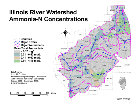
- 51 Ammonia-N Concentrations in the Illinois River Watershed
- Thematic map showing the mean total Ammonia-N for each of the major sub-watersheds.
- Download Options: LoRes preview | HiRes (624 K) | Metadata
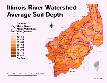
- 52 Average soil depth in the Illinois River Watershed
- Thematic map showing the average soil depth (inches) across the basin.
- Download Options: LoRes preview | HiRes (3.36 MB) | Metadata
- 53 Bureau County Coal Maps
- ISGS Coal Map Series. Includes mines, resources, and logs.
- 54 Bureau County Orthophotography Data 1998-1999
- Illinois National Aerial Photography Program Digital Orthophotography quarter Quadrangle data for Bureau County in the Universal Transverse Mercator (UTM) coordinate system with a NAD83 datum.

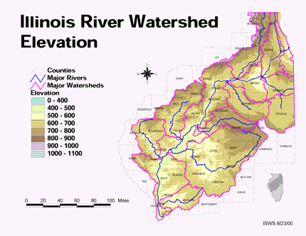
- 55 Elevation in the Illinois River Watershed
- Thematic map showing elevation changes in the basin.
- Download Options: LoRes preview | HiRes (1.76 MB) | Metadata
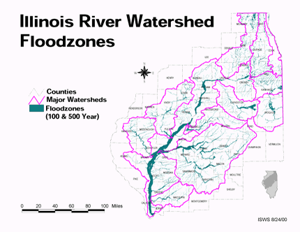
- 56 Floodzones in the Illinois River Watershed
- Thematic map showing the 100 and 500 year floodzones across the basin as of 1986.
- Download Options: LoRes preview | HiRes (3.77 MB) | Metadata
- 57 Fulton County Coal Maps
- ISGS Coal Map Series. Includes mines, resources, and logs.
- 58 Fulton County Orthophotography Data 1998-1999
- Illinois National Aerial Photography Program Digital Orthophotography quarter Quadrangle data for Fulton County in the Universal Transverse Mercator (UTM) coordinate system with a NAD83 datum.
- 59 Henry County Coal Maps
- ISGS Coal Map Series. Includes mines, resources, and logs.
- 60 Henry County Orthophotography Data 1998-1999
- Illinois National Aerial Photography Program Digital Orthophotography quarter Quadrangle data for Henry County in the Universal Transverse Mercator (UTM) coordinate system with a NAD83 datum.
Page: [<< Prev] 1 | 2 | 3 | 4 | 5 | 6 | 7 | 8 | 9 | 10 | 11 | [Next >>]
- Home
- | Data
- | Maps/GIS
- | Models
- | Publications
- | Research
- | Agencies
- | Visualizations
All files and information © 2018 Illinois State Water Survey. Disclaimer.
Email the Web Administrator with questions or comments.