
- Home

- Watersheds - Sangamon
- Search Results
Search Results
Search Results For:
Watershed > Sangamon
283 links were found.
Jump to: Data Online Maps/GIS Models Publications Research and Programs Agencies/Organizations
Displaying Page 7 (of 15)
Page: [<< Prev] 1 | 2 | 3 | 4 | 5 | 6 | 7 | 8 | 9 | 10 | 11 | 12 | 13 | 14 | 15 | [Next >>]
Maps/GIS- 121 Menard County Coal Maps
- ISGS Coal Map Series. Includes mines, resources, and logs.
- 122 Menard County Orthophotography Data 1998-1999
- Illinois National Aerial Photography Program Digital Orthophotography quarter Quadrangle data for Menard County in the Universal Transverse Mercator (UTM) coordinate system with a NAD83 datum.

- 123 Montgomery County Coal Maps
- ISGS Coal Map Series. Includes mines, resources, and logs.
- 124 Montgomery County Orthophotography Data 1998-1999
- Illinois National Aerial Photography Program Digital Orthophotography quarter Quadrangle data for Montgomery County in the Universal Transverse Mercator (UTM) coordinate system with a NAD83 datum.
- 125 Morgan County Coal Maps
- ISGS Coal Map Series. Includes mines, resources, and logs.
- 126 Morgan County Orthophotography Data 1998-1999
- Illinois National Aerial Photography Program Digital Orthophotography quarter Quadrangle data for Morgan County in the Universal Transverse Mercator (UTM) coordinate system with a NAD83 datum.
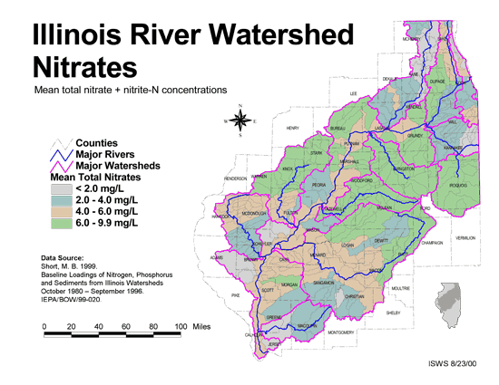
- 127 Nitrates in the Illinois River Watershed (mean total nitrate + nitrite-N concentrations)
- Thematic map showing the mean total nitrate + nitrite-N concentrations for each of the major sub-watersheds.
- Download Options: LoRes preview | HiRes (624 K) | Metadata
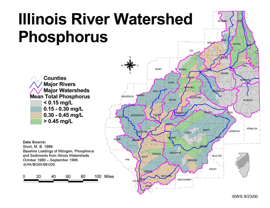
- 128 Phosphorus in the Illinois River Watershed
- Thematic map showing the mean total phosphorus concentrations for each of the major sub-watersheds.
- Download Options: LoRes preview | HiRes (624 K) | Metadata
- 129 Piatt County Coal Maps
- ISGS Coal Map Series. Includes mines, resources, and logs.
- 130 Piatt County Orthophotography Data 1998-1999
- Illinois National Aerial Photography Program Digital Orthophotography quarter Quadrangle data for Piatt County in the Universal Transverse Mercator (UTM) coordinate system with a NAD83 datum.
- 131 Resource Management Mapping Service
- Interactive map that allows users to locate, create, and print maps of large and small areas within Illinois. Natural resource, administrative, and economic layers available.
- 132 Sangamon County Coal Maps
- ISGS Coal Map Series. Includes mines, resources, and logs.
- 133 Sangamon County Orthophotography Data 1998-1999
- Illinois National Aerial Photography Program Digital Orthophotography quarter Quadrangle data for Sangamon County in the Universal Transverse Mercator (UTM) coordinate system with a NAD83 datum.
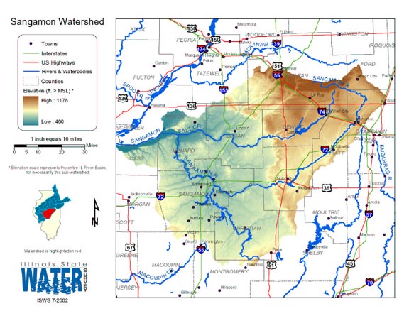
- 134 Sangamon Watershed map
- Thematic map of the Sangamon watershed showing roads, county boundaries, and elevation changes.
- Download Options: LoRes preview | HiRes (2.50 MB) | Metadata
- 135 Sediment delivery to the main stem of the Illinois River
- Using sediment delivery classes, this map describes sediment delivery to the Illinois River from the major sub-watersheds.
- Download Options: LoRes preview | HiRes (630 K) | Metadata
- 136 Shelby County Coal Maps
- ISGS Coal Map Series. Includes mines, resources, and logs.
- 137 Shelby County Orthophotography Data 1998-1999
- Illinois National Aerial Photography Program Digital Orthophotography quarter Quadrangle data for Shelby County in the Universal Transverse Mercator (UTM) coordinate system with a NAD83 datum.
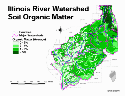
- 138 Soil organic matter in the Illinois River Watershed
- Thematic map showing the percent organic matter for each of the major sub-watersheds.
- Download Options: LoRes preview | HiRes (4.69 MB) | Metadata
- 139 Tazewell County Coal Maps
- ISGS Coal Map Series. Includes mines, resources, and logs.
- 140 Tazewell County Orthophotography Data 1998-1999
- Illinois National Aerial Photography Program Digital Orthophotography quarter Quadrangle data for Tazewell County in the Universal Transverse Mercator (UTM) coordinate system with a NAD83 datum.
Page: [<< Prev] 1 | 2 | 3 | 4 | 5 | 6 | 7 | 8 | 9 | 10 | 11 | 12 | 13 | 14 | 15 | [Next >>]
- Home
- | Data
- | Maps/GIS
- | Models
- | Publications
- | Research
- | Agencies
- | Visualizations
All files and information © 2018 Illinois State Water Survey. Disclaimer.
Email the Web Administrator with questions or comments.