
- Home

- Watersheds - Sangamon
- Search Results
Search Results
Search Results For:
Watershed > Sangamon
283 links were found.
Jump to: Data Online Maps/GIS Models Publications Research and Programs Agencies/Organizations
Displaying Page 6 (of 15)
Page: [<< Prev] 1 | 2 | 3 | 4 | 5 | 6 | 7 | 8 | 9 | 10 | 11 | 12 | 13 | 14 | 15 | [Next >>]
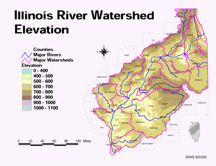
Maps/GIS- 101 Elevation in the Illinois River Watershed
- Thematic map showing elevation changes in the basin.
- Download Options: LoRes preview | HiRes (1.76 MB) | Metadata
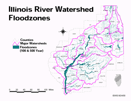
- 102 Floodzones in the Illinois River Watershed
- Thematic map showing the 100 and 500 year floodzones across the basin as of 1986.
- Download Options: LoRes preview | HiRes (3.77 MB) | Metadata
- 103 Ford County Coal Maps
- ISGS Coal Map Series. Includes mines, resources, and logs.
- 104 Ford County Orthophotography Data 1998-1999
- Illinois National Aerial Photography Program Digital Orthophotography quarter Quadrangle data for Ford County in the Universal Transverse Mercator (UTM) coordinate system with a NAD83 datum.

- 105 Illinois Floodplain Maps
- ISWS resource providing preliminary and final maps of Illinois floodplains.
- 106 Illinois River Basin GIS Data Viewer
- Interactive map provided by the ISWS. Viewable layers include watersheds, rivers, water quality, geology, and groundwater.
- 107 Illinois River Basin Weather Stations
- The weather stations in this data set were gathered from the WDM database within the Basins watershed modeling program. Coordinates for the stations were exported from Basins, then formatted and imported into ArcGIS. This data set was created to support research at the Illinois State Water Survey. (shapefile, .zip archive)
- 108 Illinois River Watershed - Poster
- Poster-sized (26x38) map of the entire Illinois River Watershed. Part of the Illinois State Water Survey published Map Series (2003-1)
- Download Options: LoRes preview | HiRes (3.5 MB) | Metadata
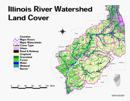
- 109 Land cover in the Illinois River Watershed
- Thematic map showing land cover from raster imagery.
- Download Options: LoRes preview | HiRes (2.68 MB) | Metadata
- 110 Logan County Coal Maps
- ISGS Coal Map Series. Includes mines, resources, and logs.
- 111 Logan County Orthophotography Data 1998-1999
- Illinois National Aerial Photography Program Digital Orthophotography quarter Quadrangle data for Logan County in the Universal Transverse Mercator (UTM) coordinate system with a NAD83 datum.
- 112 Macon County Coal Maps
- ISGS Coal Map Series. Includes mines, resources, and logs.
- 113 Macon County Orthophotography Data 1998-1999
- Illinois National Aerial Photography Program Digital Orthophotography quarter Quadrangle data for Macon County in the Universal Transverse Mercator (UTM) coordinate system with a NAD83 datum.
- 114 Macoupin County Coal Maps
- ISGS Coal Map Series. Includes mines, resources, and logs.
- 115 Macoupin County Orthophotography Data 1998-1999
- Illinois National Aerial Photography Program Digital Orthophotography quarter Quadrangle data for Macoupin County in the Universal Transverse Mercator (UTM) coordinate system with a NAD83 datum.
- 116 Major Watersheds of Illinois
- Poster-sized (26x38) map of the major watersheds in Illinois. Part of the Illinois State Water Survey published Map Series (2000-01)
- Download Options: LoRes preview | HiRes (730 K) | Metadata
- 117 Mason County Coal Maps
- ISGS Coal Map Series. Includes mines, resources, and logs.
- 118 Mason County Orthophotography Data 1998-1999
- Illinois National Aerial Photography Program Digital Orthophotography quarter Quadrangle data for Mason County in the Universal Transverse Mercator (UTM) coordinate system with a NAD83 datum.
- 119 McLean County Coal Maps
- ISGS Coal Map Series. Includes mines, resources, and logs.
- 120 McLean County Orthophotography Data 1998-1999
- Illinois National Aerial Photography Program Digital Orthophotography quarter Quadrangle data for McLean County in the Universal Transverse Mercator (UTM) coordinate system with a NAD83 datum.
Page: [<< Prev] 1 | 2 | 3 | 4 | 5 | 6 | 7 | 8 | 9 | 10 | 11 | 12 | 13 | 14 | 15 | [Next >>]
- Home
- | Data
- | Maps/GIS
- | Models
- | Publications
- | Research
- | Agencies
- | Visualizations
All files and information © 2018 Illinois State Water Survey. Disclaimer.
Email the Web Administrator with questions or comments.