
- Home

- Watersheds - Illinois River Valley
- Search Results
Search Results
Search Results For:
Watershed > Illinois River Valley
443 links were found.
Jump to: Data Online Maps/GIS Models Publications Research and Programs Agencies/Organizations Visualizations/Video
Displaying Page 9 (of 23)
Page: [<< Prev] 1 | 2 | 3 | 4 | 5 | 6 | 7 | 8 | 9 | 10 | 11 | 12 | 13 | 14 | 15 | 16 | 17 | 18 | 19 | 20 | 21 | 22 | 23 | [Next >>]
Maps/GIS- 161 Sangamon County Coal Maps
- ISGS Coal Map Series. Includes mines, resources, and logs.
- 162 Sangamon County Orthophotography Data 1998-1999
- Illinois National Aerial Photography Program Digital Orthophotography quarter Quadrangle data for Sangamon County in the Universal Transverse Mercator (UTM) coordinate system with a NAD83 datum.

- 163 Schuyler County Coal Maps
- ISGS Coal Map Series. Includes mines, resources, and logs.
- 164 Schuyler County Orthophotography Data 1998-1999
- Illinois National Aerial Photography Program Digital Orthophotography quarter Quadrangle data for Schuyler County in the Universal Transverse Mercator (UTM) coordinate system with a NAD83 datum.
- 165 Scott County Coal Maps
- ISGS Coal Map Series. Includes mines, resources, and logs.
- 166 Scott County Orthophotography Data 1998-1999
- Illinois National Aerial Photography Program Digital Orthophotography quarter Quadrangle data for Scott County in the Universal Transverse Mercator (UTM) coordinate system with a NAD83 datum.
- 167 Sediment delivery to the main stem of the Illinois River
- Using sediment delivery classes, this map describes sediment delivery to the Illinois River from the major sub-watersheds.
- Download Options: LoRes preview | HiRes (630 K) | Metadata
- 168 Soil organic matter in the Illinois River Watershed
- Thematic map showing the percent organic matter for each of the major sub-watersheds.
- Download Options: LoRes preview | HiRes (4.69 MB) | Metadata
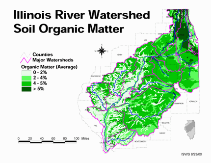
- 169 Tazewell County Coal Maps
- ISGS Coal Map Series. Includes mines, resources, and logs.
- 170 Tazewell County Orthophotography Data 1998-1999
- Illinois National Aerial Photography Program Digital Orthophotography quarter Quadrangle data for Tazewell County in the Universal Transverse Mercator (UTM) coordinate system with a NAD83 datum.
- 171 Total suspended solids in the Illinois River Watershed
- Thematic map showing the mean TSS concentrations for each of the major sub-watersheds.
- Download Options: LoRes preview | HiRes (626 K) | Metadata
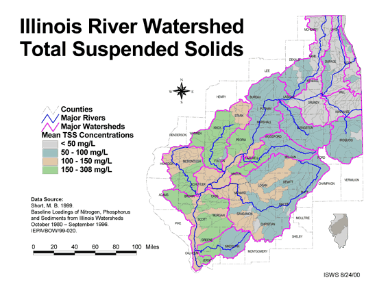
- 172 Will County Coal Maps
- ISGS Coal Map Series. Includes mines, resources, and logs.
- 173 Will County Orthophotography Data 1998-1999
- Illinois National Aerial Photography Program Digital Orthophotography quarter Quadrangle data for Will County in the Universal Transverse Mercator (UTM) coordinate system with a NAD83 datum.
- 174 Woodford County Coal Maps
- ISGS Coal Map Series. Includes mines, resources, and logs.
- 175 Woodford County Orthophotography Data 1998-1999
- Illinois National Aerial Photography Program Digital Orthophotography quarter Quadrangle data for Woodford County in the Universal Transverse Mercator (UTM) coordinate system with a NAD83 datum.
- 176 Watershed Models
- Links to simple overviews of various landscape/watershed simulation models. Site maintained by the Environmental Protection Agency.
 = Abstract available
  = Full Text available
  = Fact Sheet available
  = PDF format
  = HTML format
  = PowerPoint format
- 177 50 Years of Change in Illinois Hill Prairies


- This publication discusses the history of Illinois hill prairies.
- Robertson, K., M. W. Schwartz, J. W. Olson, B. K. Dunphy, and H. D. Clarke, 1995 Illinois Native Plant Society
- 178 A Resting Place for the Ducks: A Multidisciplinary Analysis of Floodplain Restoration of the Hennepin Levee District, Illinois

- Online masters project report
- Ching-Wen Chang, Daniel G. Gaebel, Janelle M. St. Pierre, Anna J. Willow, 2001 University of Michigan, School of Natural Resources and Environment Masters project
- 179 A technique for evaluating algal growth potential in Illinois surface waters
- Wang, Wun-Cheng, William T. Sullivan, and Ralph L. Evans, 1973 ISWS RI-72
- 180 Adequacy and economics of water supply in northeastern Illinois, 1985-2010
- Singh, Krishan P., and J. Rodger Adams, 1980 ISWS RI-97
Page: [<< Prev] 1 | 2 | 3 | 4 | 5 | 6 | 7 | 8 | 9 | 10 | 11 | 12 | 13 | 14 | 15 | 16 | 17 | 18 | 19 | 20 | 21 | 22 | 23 | [Next >>]
- Home
- | Data
- | Maps/GIS
- | Models
- | Publications
- | Research
- | Agencies
- | Visualizations
All files and information © 2018 Illinois State Water Survey. Disclaimer.
Email the Web Administrator with questions or comments.