
- Home

- Rivers - Illinois
- Search Results
Search Results
Search Results For:
River > Illinois
152 links were found.
Jump to: Data Online Maps/GIS Publications Research and Programs Agencies/Organizations Visualizations/Video
Displaying Page 2 (of 8)
Page: [<< Prev] 1 | 2 | 3 | 4 | 5 | 6 | 7 | 8 | [Next >>]
Data Online- 21 ILLINOIS RIVER AT SENECA, IL - Water Data
- The USGS National Water Information System provides real-time and historical data on surface water flow, ground water levels, and water quality of streams in the US.
- 22 ILLINOIS RIVER AT SOUTH ROME, IL - Water Data
- The USGS National Water Information System provides real-time and historical data on surface water flow, ground water levels, and water quality of streams in the US.
- 23 ILLINOIS RIVER AT STARVED ROCK, IL - Water Data
- The USGS National Water Information System provides real-time and historical data on surface water flow, ground water levels, and water quality of streams in the US.
- 24 ILLINOIS RIVER AT VALLEY CITY, IL - Water Data
- The USGS National Water Information System provides real-time and historical data on surface water flow, ground water levels, and water quality of streams in the US.
- 25 ILLINOIS RIVER AT WATER COMPANY AT PEORIA, IL - Water Data
- The USGS National Water Information System provides real-time and historical data on surface water flow, ground water levels, and water quality of streams in the US.
- 26 ILLINOIS RIVER BELOW PEORIA LAKE AT PEORIA, IL - Water Data
- The USGS National Water Information System provides real-time and historical data on surface water flow, ground water levels, and water quality of streams in the US.
- 27 ILLINOIS RIVER NEAR STOCKDALE, IL - Water Data
- The USGS National Water Information System provides real-time and historical data on surface water flow, ground water levels, and water quality of streams in the US.
- 28 Illinois River Stage Data and Forecasts
- Data provided by the National Weather Services Advanced Hydrologic Prediction Service
- 29 Illinois Water Quality
- EPA maintained website with links to all Illinois watershed water quality summary reports dating back to 1996.
- 30 Illinois Waterway Navigation Notices
- US Army Corps of Engineers maintained webpage listing of public navigational notices.
- 31 Instantaneous Suspended Sediment Data
- The Benchmark Sediment Monitoring Program offers weekly data from suspended sediment samples collected at fifteen sampling sites throughout Illinois. Available in HTML and .csv formats.
- 32 National Weather Service
- Provides weather, water, and climate data, forecasts and warnings.
- 33 Provisional Monthly Flow Data
- This site shows provisional, monthly mean flow data for 26 US Geological Survey gaging stations on rivers and streams throughout Illinois.
- 34 Rivergages.com: Water Levels of Rivers and Lakes
- US Army Corps of Engineers maintained interface to easily access water level data for all Illinois Waterway measurement stations in tabular, graphical, or downloadable form. Divided by watershed.
- 35 Water Quality Database
- Database of water quality measurements along the Illinois River, maintained by the ISWS. Searchable by location or characteristic (Alkalinity, Fluoride, etc.).
- 36 1993 Mississippi River Flood Hazard Mitigation Grant Program
- 1993 Mississippi River flood maps that show properties damaged in the event.
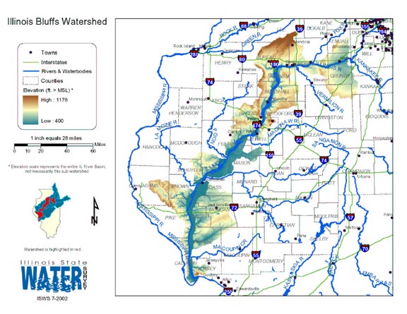
- 37 Illinois Bluffs Watershed
- Thematic map of the Illinois Bluffs watershed showing roads, county boundaries, and elevation changes.
- Download Options: LoRes preview | HiRes (2.26 MB) | Metadata
- 38 Illinois River Basin GIS Data Viewer
- Interactive map provided by the ISWS. Viewable layers include watersheds, rivers, water quality, geology, and groundwater.
- 39 Illinois River Watershed - Poster
- Poster-sized (26x38) map of the entire Illinois River Watershed. Part of the Illinois State Water Survey published Map Series (2003-1)
- Download Options: LoRes preview | HiRes (3.5 MB) | Metadata
- 40 Resource Management Mapping Service
- Interactive map that allows users to locate, create, and print maps of large and small areas within Illinois. Natural resource, administrative, and economic layers available.
- Home
- | Data
- | Maps/GIS
- | Models
- | Publications
- | Research
- | Agencies
- | Visualizations
All files and information © 2018 Illinois State Water Survey. Disclaimer.
Email the Web Administrator with questions or comments.